You are here: Home > Network List > MN - MEDNET Project Stations List
> Station CLTB Caltabellotta, Italy > Earthquake Result Viewer
CLTB Caltabellotta, Italy - Earthquake Result Viewer
| Earthquake location: |
Kuril Islands |
| Earthquake latitude/longitude: |
45.4/149.3 |
| Earthquake time(UTC): |
2006/06/22 (173) 10:53:11 GMT |
| Earthquake Depth: |
95 km |
| Earthquake Magnitude: |
6.1 MB, 6.0 MW, 5.9 MW |
| Earthquake Catalog/Contributor: |
WHDF/NEIC |
|
| Network: |
MN MEDNET Project |
| Station: |
CLTB Caltabellotta, Italy |
| Lat/Lon: |
37.58 N/13.22 E |
| Elevation: |
949 m |
|
| Distance: |
88.4 deg |
| Az: |
326.575 deg |
| Baz: |
29.231 deg |
| Ray Param: |
0.042409573 |
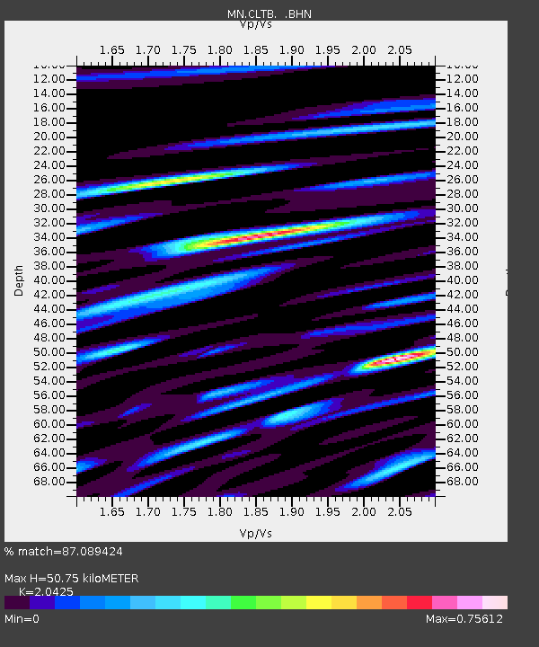
| Estimated Moho Depth: |
50.75 km |
| Estimated Crust Vp/Vs: |
2.04 |
| Assumed Crust Vp: |
5.657 km/s |
| Estimated Crust Vs: |
2.77 km/s |
| Estimated Crust Poisson's Ratio: |
0.34 |
|
| Radial Match: |
87.089424 % |
| Radial Bump: |
400 |
| Transverse Match: |
93.10574 % |
| Transverse Bump: |
400 |
| SOD ConfigId: |
2665 |
| Insert Time: |
2010-03-08 16:59:18.696 +0000 |
| GWidth: |
2.5 |
| Max Bumps: |
400 |
| Tol: |
0.001 |
|

Signal To Noise
| Channel | StoN | STA | LTA |
| MN:CLTB: :BHN:20060622T11:05:21.83001Z | 3.1583939 | 3.9846827E-7 | 1.2616168E-7 |
| MN:CLTB: :BHE:20060622T11:05:21.83001Z | 2.4372084 | 1.9451862E-7 | 7.981206E-8 |
| MN:CLTB: :BHZ:20060622T11:05:21.83001Z | 3.2946298 | 2.7429286E-7 | 8.325453E-8 |
| Arrivals |
| Ps | 9.5 SECOND |
| PpPs | 27 SECOND |
| PsPs/PpSs | 36 SECOND |


