You are here: Home > Network List > MN - MEDNET Project Stations List
> Station CLTB Caltabellotta, Italy > Earthquake Result Viewer
CLTB Caltabellotta, Italy - Earthquake Result Viewer
| Earthquake location: |
Kuril Islands |
| Earthquake latitude/longitude: |
44.3/148.4 |
| Earthquake time(UTC): |
2001/05/25 (145) 00:40:50 GMT |
| Earthquake Depth: |
33 km |
| Earthquake Magnitude: |
6.1 MB, 6.7 MS, 6.7 MW, 6.6 MW |
| Earthquake Catalog/Contributor: |
WHDF/NEIC |
|
| Network: |
MN MEDNET Project |
| Station: |
CLTB Caltabellotta, Italy |
| Lat/Lon: |
37.58 N/13.22 E |
| Elevation: |
949 m |
|
| Distance: |
89.0 deg |
| Az: |
325.934 deg |
| Baz: |
30.431 deg |
| Ray Param: |
0.04213319 |
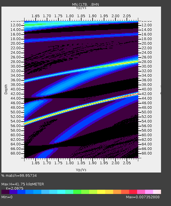
| Estimated Moho Depth: |
41.75 km |
| Estimated Crust Vp/Vs: |
2.10 |
| Assumed Crust Vp: |
5.657 km/s |
| Estimated Crust Vs: |
2.697 km/s |
| Estimated Crust Poisson's Ratio: |
0.35 |
|
| Radial Match: |
99.95734 % |
| Radial Bump: |
7 |
| Transverse Match: |
67.45203 % |
| Transverse Bump: |
400 |
| SOD ConfigId: |
4714 |
| Insert Time: |
2010-03-08 16:59:29.890 +0000 |
| GWidth: |
2.5 |
| Max Bumps: |
400 |
| Tol: |
0.001 |
|

Signal To Noise
| Channel | StoN | STA | LTA |
| MN:CLTB: :BHN:20010525T00:53:10.790002Z | 3.110654 | 4.0632966E-7 | 1.3062515E-7 |
| MN:CLTB: :BHE:20010525T00:53:10.790002Z | 2.3405974 | 3.291015E-7 | 1.4060578E-7 |
| MN:CLTB: :BHZ:20010525T00:53:10.790002Z | 4.9979463 | 6.995783E-7 | 1.3997315E-7 |
| Arrivals |
| Ps | 8.2 SECOND |
| PpPs | 23 SECOND |
| PsPs/PpSs | 31 SECOND |


