You are here: Home > Network List > AG - Arkansas Seismic Network Stations List
> Station WHAR Woolly Hollow State Park,AR > Earthquake Result Viewer
WHAR Woolly Hollow State Park,AR - Earthquake Result Viewer
| Earthquake location: |
Vancouver Island, Canada Region |
| Earthquake latitude/longitude: |
50.6/-130.0 |
| Earthquake time(UTC): |
2019/12/25 (359) 03:36:02 GMT |
| Earthquake Depth: |
10 km |
| Earthquake Magnitude: |
6.3 mww |
| Earthquake Catalog/Contributor: |
NEIC PDE/us |
|
| Network: |
AG Arkansas Seismic Network |
| Station: |
WHAR Woolly Hollow State Park,AR |
| Lat/Lon: |
35.29 N/92.29 W |
| Elevation: |
184 m |
|
| Distance: |
31.2 deg |
| Az: |
104.775 deg |
| Baz: |
311.104 deg |
| Ray Param: |
0.07917813 |
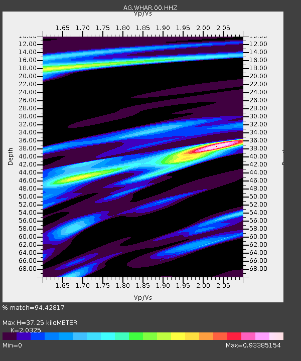
| Estimated Moho Depth: |
37.25 km |
| Estimated Crust Vp/Vs: |
2.03 |
| Assumed Crust Vp: |
6.498 km/s |
| Estimated Crust Vs: |
3.197 km/s |
| Estimated Crust Poisson's Ratio: |
0.34 |
|
| Radial Match: |
94.42817 % |
| Radial Bump: |
256 |
| Transverse Match: |
77.82328 % |
| Transverse Bump: |
400 |
| SOD ConfigId: |
20465011 |
| Insert Time: |
2020-01-08 03:36:15.706 +0000 |
| GWidth: |
2.5 |
| Max Bumps: |
400 |
| Tol: |
0.001 |
|

Signal To Noise
| Channel | StoN | STA | LTA |
| AG:WHAR:00:HHZ:20191225T03:41:50.814986Z | 4.2873487 | 1.8840824E-6 | 4.3945167E-7 |
| AG:WHAR:00:HHN:20191225T03:41:50.814986Z | 2.713937 | 5.9327607E-7 | 2.1860349E-7 |
| AG:WHAR:00:HHE:20191225T03:41:50.814986Z | 1.5627587 | 6.628102E-7 | 4.241283E-7 |
| Arrivals |
| Ps | 6.4 SECOND |
| PpPs | 16 SECOND |
| PsPs/PpSs | 23 SECOND |


