You are here: Home > Network List > TS - TERRAscope (Southern California Seismic Network) Stations List
> Station PAS Pasadena, California, USA > Earthquake Result Viewer
PAS Pasadena, California, USA - Earthquake Result Viewer
*The percent match for this event was below the threshold and hence no stack was calculated.
| Earthquake location: |
Mariana Islands |
| Earthquake latitude/longitude: |
18.6/145.5 |
| Earthquake time(UTC): |
1991/10/26 (299) 02:27:31 GMT |
| Earthquake Depth: |
193 km |
| Earthquake Magnitude: |
5.8 MB |
| Earthquake Catalog/Contributor: |
WHDF/NEIC |
|
| Network: |
TS TERRAscope (Southern California Seismic Network) |
| Station: |
PAS Pasadena, California, USA |
| Lat/Lon: |
34.15 N/118.17 W |
| Elevation: |
295 m |
|
| Distance: |
84.8 deg |
| Az: |
55.87 deg |
| Baz: |
288.787 deg |
| Ray Param: |
$rayparam |
*The percent match for this event was below the threshold and hence was not used in the summary stack. |
|
| Radial Match: |
47.771534 % |
| Radial Bump: |
400 |
| Transverse Match: |
72.450905 % |
| Transverse Bump: |
400 |
| SOD ConfigId: |
4480 |
| Insert Time: |
2010-02-26 14:38:48.375 +0000 |
| GWidth: |
2.5 |
| Max Bumps: |
400 |
| Tol: |
0.001 |
|
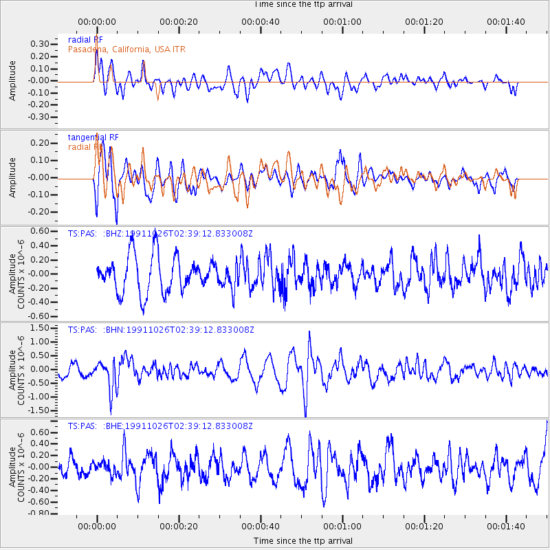
Signal To Noise
| Channel | StoN | STA | LTA |
| TS:PAS: :BHN:19911026T02:39:12.833008Z | 3.2334363 | 5.212711E-7 | 1.6121274E-7 |
| TS:PAS: :BHE:19911026T02:39:12.833008Z | 0.7725525 | 1.0460639E-7 | 1.3540361E-7 |
| TS:PAS: :BHZ:19911026T02:39:12.833008Z | 0.6474122 | 1.7355758E-7 | 2.6807896E-7 |
| Arrivals |
| Ps | |
| PpPs | |
| PsPs/PpSs | |


