You are here: Home > Network List > N4 - Central and EAstern US Network Stations List
> Station P48A Milroy, IN, USA > Earthquake Result Viewer
P48A Milroy, IN, USA - Earthquake Result Viewer
| Earthquake location: |
Vancouver Island, Canada Region |
| Earthquake latitude/longitude: |
50.6/-130.0 |
| Earthquake time(UTC): |
2019/12/25 (359) 03:36:02 GMT |
| Earthquake Depth: |
10 km |
| Earthquake Magnitude: |
6.3 mww |
| Earthquake Catalog/Contributor: |
NEIC PDE/us |
|
| Network: |
N4 Central and EAstern US Network |
| Station: |
P48A Milroy, IN, USA |
| Lat/Lon: |
39.46 N/85.43 W |
| Elevation: |
300 m |
|
| Distance: |
32.9 deg |
| Az: |
92.249 deg |
| Baz: |
304.628 deg |
| Ray Param: |
0.07843869 |
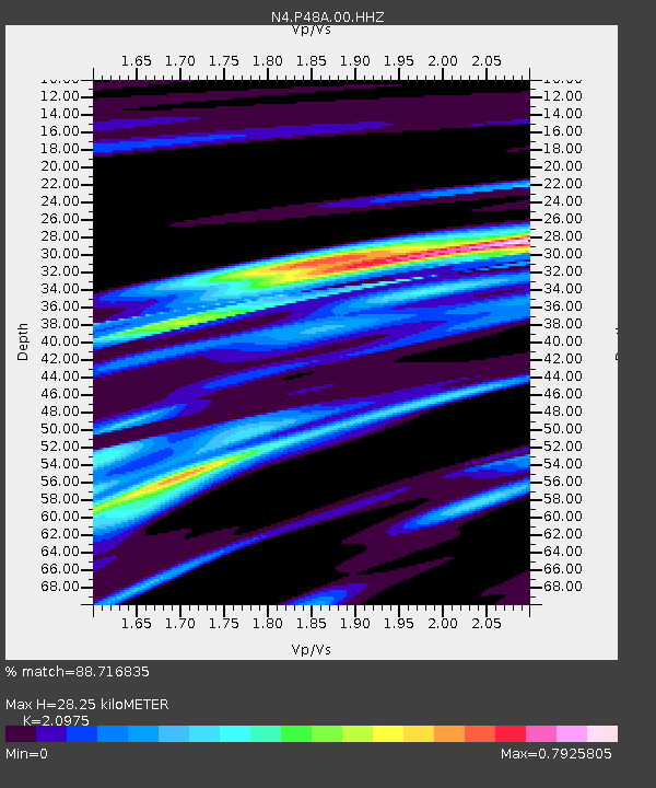
| Estimated Moho Depth: |
28.25 km |
| Estimated Crust Vp/Vs: |
2.10 |
| Assumed Crust Vp: |
6.498 km/s |
| Estimated Crust Vs: |
3.098 km/s |
| Estimated Crust Poisson's Ratio: |
0.35 |
|
| Radial Match: |
88.716835 % |
| Radial Bump: |
318 |
| Transverse Match: |
62.97799 % |
| Transverse Bump: |
400 |
| SOD ConfigId: |
20465011 |
| Insert Time: |
2020-01-08 03:43:23.407 +0000 |
| GWidth: |
2.5 |
| Max Bumps: |
400 |
| Tol: |
0.001 |
|

Signal To Noise
| Channel | StoN | STA | LTA |
| N4:P48A:00:HHZ:20191225T03:42:06.349013Z | 4.2224 | 2.2768807E-6 | 5.3923844E-7 |
| N4:P48A:00:HH1:20191225T03:42:06.349013Z | 1.7347405 | 6.219184E-7 | 3.58508E-7 |
| N4:P48A:00:HH2:20191225T03:42:06.349013Z | 2.0184586 | 1.2811222E-6 | 6.347032E-7 |
| Arrivals |
| Ps | 5.1 SECOND |
| PpPs | 13 SECOND |
| PsPs/PpSs | 18 SECOND |


