You are here: Home > Network List > N4 - Central and EAstern US Network Stations List
> Station V53A Sandy Mush, NC, USA > Earthquake Result Viewer
V53A Sandy Mush, NC, USA - Earthquake Result Viewer
| Earthquake location: |
Vancouver Island, Canada Region |
| Earthquake latitude/longitude: |
50.6/-130.0 |
| Earthquake time(UTC): |
2019/12/25 (359) 03:36:02 GMT |
| Earthquake Depth: |
10 km |
| Earthquake Magnitude: |
6.3 mww |
| Earthquake Catalog/Contributor: |
NEIC PDE/us |
|
| Network: |
N4 Central and EAstern US Network |
| Station: |
V53A Sandy Mush, NC, USA |
| Lat/Lon: |
35.67 N/82.81 W |
| Elevation: |
681 m |
|
| Distance: |
36.9 deg |
| Az: |
95.381 deg |
| Baz: |
308.786 deg |
| Ray Param: |
0.07647469 |
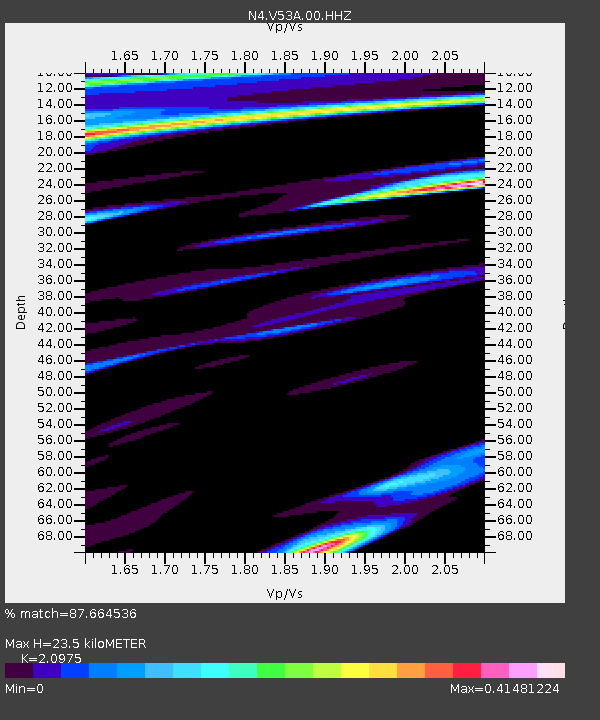
| Estimated Moho Depth: |
23.5 km |
| Estimated Crust Vp/Vs: |
2.10 |
| Assumed Crust Vp: |
6.35 km/s |
| Estimated Crust Vs: |
3.027 km/s |
| Estimated Crust Poisson's Ratio: |
0.35 |
|
| Radial Match: |
87.664536 % |
| Radial Bump: |
397 |
| Transverse Match: |
50.191315 % |
| Transverse Bump: |
400 |
| SOD ConfigId: |
20465011 |
| Insert Time: |
2020-01-08 03:43:52.978 +0000 |
| GWidth: |
2.5 |
| Max Bumps: |
400 |
| Tol: |
0.001 |
|

Signal To Noise
| Channel | StoN | STA | LTA |
| N4:V53A:00:HHZ:20191225T03:42:40.15901Z | 2.3413725 | 1.0685285E-6 | 4.5636844E-7 |
| N4:V53A:00:HH1:20191225T03:42:40.15901Z | 1.9118296 | 5.207823E-7 | 2.7239994E-7 |
| N4:V53A:00:HH2:20191225T03:42:40.15901Z | 1.3843796 | 5.092902E-7 | 3.6788333E-7 |
| Arrivals |
| Ps | 4.3 SECOND |
| PpPs | 11 SECOND |
| PsPs/PpSs | 15 SECOND |


