You are here: Home > Network List > N4 - Central and EAstern US Network Stations List
> Station W50A Signal Mountain, TN, USA > Earthquake Result Viewer
W50A Signal Mountain, TN, USA - Earthquake Result Viewer
| Earthquake location: |
Vancouver Island, Canada Region |
| Earthquake latitude/longitude: |
50.6/-130.0 |
| Earthquake time(UTC): |
2019/12/25 (359) 03:36:02 GMT |
| Earthquake Depth: |
10 km |
| Earthquake Magnitude: |
6.3 mww |
| Earthquake Catalog/Contributor: |
NEIC PDE/us |
|
| Network: |
N4 Central and EAstern US Network |
| Station: |
W50A Signal Mountain, TN, USA |
| Lat/Lon: |
35.20 N/85.31 W |
| Elevation: |
587 m |
|
| Distance: |
35.6 deg |
| Az: |
98.177 deg |
| Baz: |
309.6 deg |
| Ray Param: |
0.07714903 |
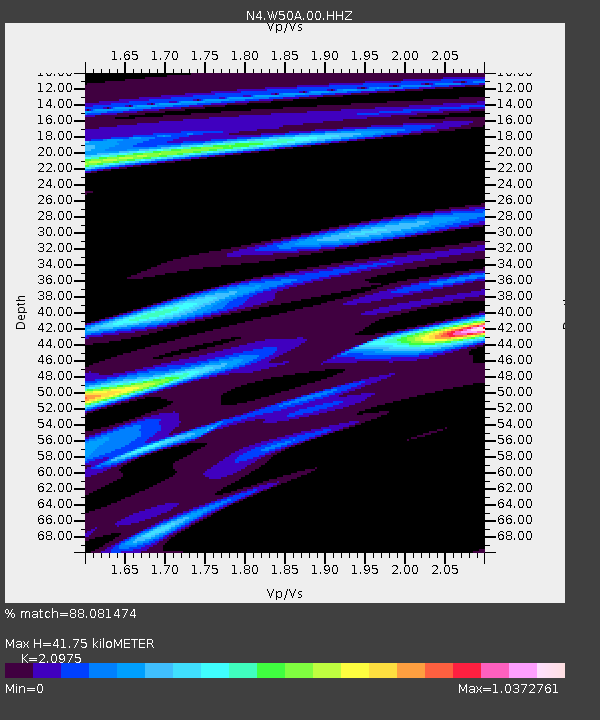
| Estimated Moho Depth: |
41.75 km |
| Estimated Crust Vp/Vs: |
2.10 |
| Assumed Crust Vp: |
6.35 km/s |
| Estimated Crust Vs: |
3.027 km/s |
| Estimated Crust Poisson's Ratio: |
0.35 |
|
| Radial Match: |
88.081474 % |
| Radial Bump: |
301 |
| Transverse Match: |
54.044563 % |
| Transverse Bump: |
381 |
| SOD ConfigId: |
20465011 |
| Insert Time: |
2020-01-08 03:43:56.128 +0000 |
| GWidth: |
2.5 |
| Max Bumps: |
400 |
| Tol: |
0.001 |
|

Signal To Noise
| Channel | StoN | STA | LTA |
| N4:W50A:00:HHZ:20191225T03:42:29.180006Z | 2.95226 | 1.1023685E-6 | 3.733982E-7 |
| N4:W50A:00:HH1:20191225T03:42:29.180006Z | 1.1006372 | 4.1103408E-7 | 3.73451E-7 |
| N4:W50A:00:HH2:20191225T03:42:29.180006Z | 2.0500517 | 5.2231695E-7 | 2.5478235E-7 |
| Arrivals |
| Ps | 7.7 SECOND |
| PpPs | 19 SECOND |
| PsPs/PpSs | 27 SECOND |


