You are here: Home > Network List > NM - Cooperative New Madrid Seismic Network Stations List
> Station HENM Henderson Mound,MO > Earthquake Result Viewer
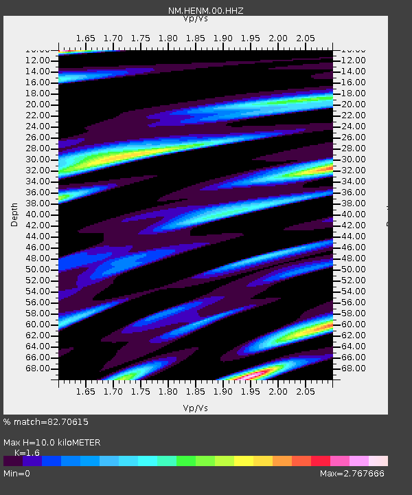
HENM Henderson Mound,MO - Earthquake Result Viewer
| Earthquake location: |
Vancouver Island, Canada Region |
| Earthquake latitude/longitude: |
50.6/-130.0 |
| Earthquake time(UTC): |
2019/12/25 (359) 03:36:02 GMT |
| Earthquake Depth: |
10 km |
| Earthquake Magnitude: |
6.3 mww |
| Earthquake Catalog/Contributor: |
NEIC PDE/us |
|
| Network: |
NM Cooperative New Madrid Seismic Network |
| Station: |
HENM Henderson Mound,MO |
| Lat/Lon: |
36.72 N/89.47 W |
| Elevation: |
88 m |
|
| Distance: |
32.0 deg |
| Az: |
99.894 deg |
| Baz: |
308.594 deg |
| Ray Param: |
0.07885109 |
| Estimated Moho Depth: |
10.0 km |
| Estimated Crust Vp/Vs: |
1.60 |
| Assumed Crust Vp: |
6.444 km/s |
| Estimated Crust Vs: |
4.027 km/s |
| Estimated Crust Poisson's Ratio: |
0.18 |
|
| Radial Match: |
82.70615 % |
| Radial Bump: |
400 |
| Transverse Match: |
73.09665 % |
| Transverse Bump: |
400 |
| SOD ConfigId: |
20465011 |
| Insert Time: |
2020-01-08 03:44:28.022 +0000 |
| GWidth: |
2.5 |
| Max Bumps: |
400 |
| Tol: |
0.001 |
|

Signal To Noise
| Channel | StoN | STA | LTA |
| NM:HENM:00:HHZ:20191225T03:41:58.205Z | 4.3143086 | 1.9358592E-6 | 4.4870671E-7 |
| NM:HENM:00:HHN:20191225T03:41:58.205Z | 1.9103311 | 1.5289356E-6 | 8.0035113E-7 |
| NM:HENM:00:HHE:20191225T03:41:58.205Z | 2.1941326 | 1.6301731E-6 | 7.429693E-7 |
| Arrivals |
| Ps | 1.0 SECOND |
| PpPs | 3.7 SECOND |
| PsPs/PpSs | 4.7 SECOND |


