You are here: Home > Network List > TS - TERRAscope (Southern California Seismic Network) Stations List
> Station PAS Pasadena, California, USA > Earthquake Result Viewer
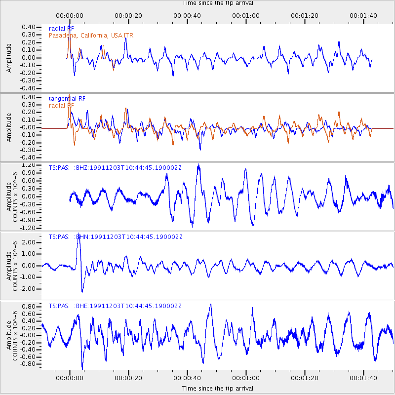
PAS Pasadena, California, USA - Earthquake Result Viewer
*The percent match for this event was below the threshold and hence no stack was calculated.
| Earthquake location: |
South Of Fiji Islands |
| Earthquake latitude/longitude: |
-26.3/178.6 |
| Earthquake time(UTC): |
1991/12/03 (337) 10:33:42 GMT |
| Earthquake Depth: |
581 km |
| Earthquake Magnitude: |
5.8 MB |
| Earthquake Catalog/Contributor: |
WHDF/NEIC |
|
| Network: |
TS TERRAscope (Southern California Seismic Network) |
| Station: |
PAS Pasadena, California, USA |
| Lat/Lon: |
34.15 N/118.17 W |
| Elevation: |
295 m |
|
| Distance: |
84.9 deg |
| Az: |
48.036 deg |
| Baz: |
233.585 deg |
| Ray Param: |
$rayparam |
*The percent match for this event was below the threshold and hence was not used in the summary stack. |
|
| Radial Match: |
58.099056 % |
| Radial Bump: |
259 |
| Transverse Match: |
63.38697 % |
| Transverse Bump: |
377 |
| SOD ConfigId: |
4480 |
| Insert Time: |
2010-02-26 14:38:49.659 +0000 |
| GWidth: |
2.5 |
| Max Bumps: |
400 |
| Tol: |
0.001 |
|
Signal To Noise
| Channel | StoN | STA | LTA |
| TS:PAS: :BHN:19911203T10:44:45.190002Z | 8.099252 | 1.3030497E-6 | 1.608852E-7 |
| TS:PAS: :BHE:19911203T10:44:45.190002Z | 2.0615888 | 4.092585E-7 | 1.9851608E-7 |
| TS:PAS: :BHZ:19911203T10:44:45.190002Z | 2.3731756 | 4.4397714E-7 | 1.8708145E-7 |
| Arrivals |
| Ps | |
| PpPs | |
| PsPs/PpSs | |


