You are here: Home > Network List > TS - TERRAscope (Southern California Seismic Network) Stations List
> Station PAS Pasadena, California, USA > Earthquake Result Viewer
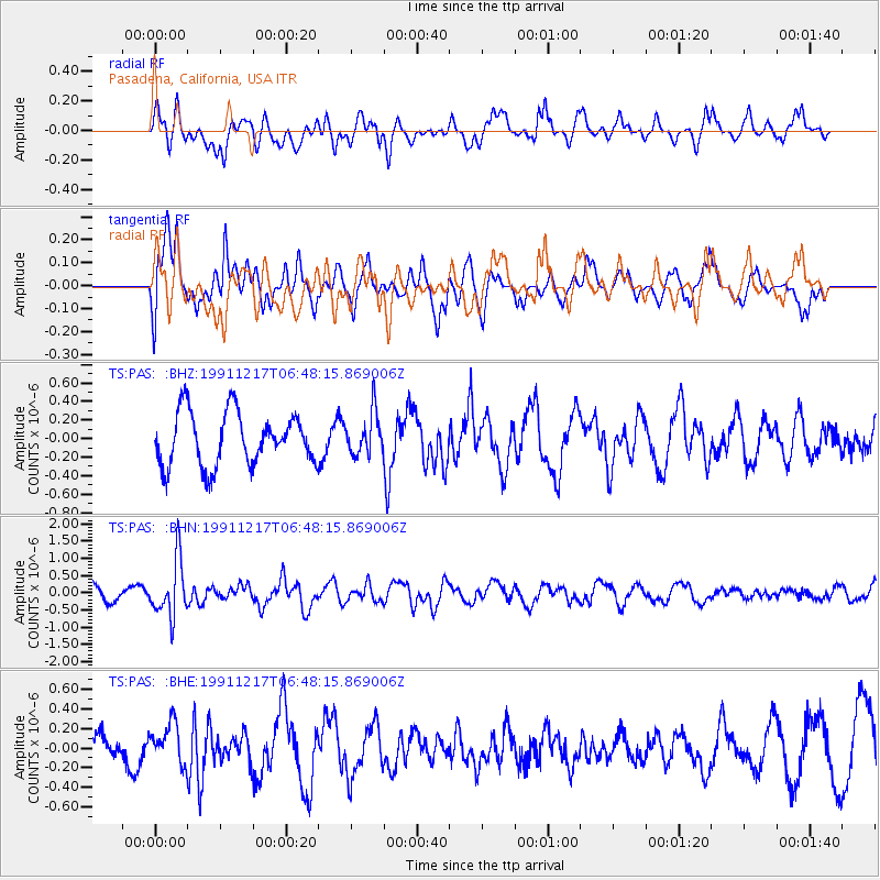
PAS Pasadena, California, USA - Earthquake Result Viewer
*The percent match for this event was below the threshold and hence no stack was calculated.
| Earthquake location: |
Kuril Islands |
| Earthquake latitude/longitude: |
47.3/151.5 |
| Earthquake time(UTC): |
1991/12/17 (351) 06:38:16 GMT |
| Earthquake Depth: |
149 km |
| Earthquake Magnitude: |
5.9 MB |
| Earthquake Catalog/Contributor: |
WHDF/NEIC |
|
| Network: |
TS TERRAscope (Southern California Seismic Network) |
| Station: |
PAS Pasadena, California, USA |
| Lat/Lon: |
34.15 N/118.17 W |
| Elevation: |
295 m |
|
| Distance: |
66.0 deg |
| Az: |
65.201 deg |
| Baz: |
311.897 deg |
| Ray Param: |
$rayparam |
*The percent match for this event was below the threshold and hence was not used in the summary stack. |
|
| Radial Match: |
65.26715 % |
| Radial Bump: |
400 |
| Transverse Match: |
57.87175 % |
| Transverse Bump: |
382 |
| SOD ConfigId: |
4480 |
| Insert Time: |
2010-02-26 14:38:51.056 +0000 |
| GWidth: |
2.5 |
| Max Bumps: |
400 |
| Tol: |
0.001 |
|
Signal To Noise
| Channel | StoN | STA | LTA |
| TS:PAS: :BHN:19911217T06:48:15.869006Z | 4.4514365 | 8.2106686E-7 | 1.8444986E-7 |
| TS:PAS: :BHE:19911217T06:48:15.869006Z | 0.94454634 | 2.0842832E-7 | 2.20665E-7 |
| TS:PAS: :BHZ:19911217T06:48:15.869006Z | 0.8050185 | 2.2936624E-7 | 2.8492045E-7 |
| Arrivals |
| Ps | |
| PpPs | |
| PsPs/PpSs | |


