You are here: Home > Network List > CN - Canadian National Seismograph Network Stations List
> Station INK INUVIK, NT > Earthquake Result Viewer
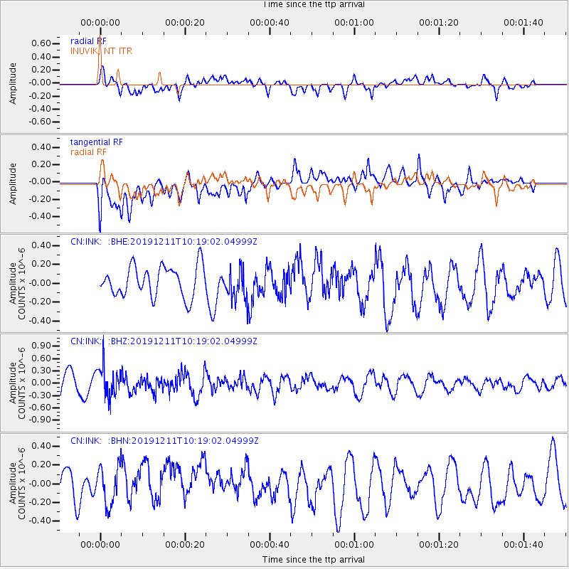
INK INUVIK, NT - Earthquake Result Viewer
*The percent match for this event was below the threshold and hence no stack was calculated.
| Earthquake location: |
Kuril Islands |
| Earthquake latitude/longitude: |
48.9/154.8 |
| Earthquake time(UTC): |
2019/12/11 (345) 10:12:07 GMT |
| Earthquake Depth: |
35 km |
| Earthquake Magnitude: |
5.1 Mww |
| Earthquake Catalog/Contributor: |
NEIC PDE/us |
|
| Network: |
CN Canadian National Seismograph Network |
| Station: |
INK INUVIK, NT |
| Lat/Lon: |
68.31 N/133.53 W |
| Elevation: |
44 m |
|
| Distance: |
39.2 deg |
| Az: |
33.909 deg |
| Baz: |
277.869 deg |
| Ray Param: |
$rayparam |
*The percent match for this event was below the threshold and hence was not used in the summary stack. |
|
| Radial Match: |
67.31532 % |
| Radial Bump: |
400 |
| Transverse Match: |
46.655483 % |
| Transverse Bump: |
400 |
| SOD ConfigId: |
20465011 |
| Insert Time: |
2020-01-09 12:19:37.516 +0000 |
| GWidth: |
2.5 |
| Max Bumps: |
400 |
| Tol: |
0.001 |
|
Signal To Noise
| Channel | StoN | STA | LTA |
| CN:INK: :BHZ:20191211T10:19:02.04999Z | 1.262541 | 3.6892195E-7 | 2.922059E-7 |
| CN:INK: :BHN:20191211T10:19:02.04999Z | 0.7786637 | 2.3533121E-7 | 3.0222446E-7 |
| CN:INK: :BHE:20191211T10:19:02.04999Z | 1.0232989 | 1.639028E-7 | 1.60171E-7 |
| Arrivals |
| Ps | |
| PpPs | |
| PsPs/PpSs | |


