You are here: Home > Network List > IU - Global Seismograph Network (GSN - IRIS/USGS) Stations List
> Station RSSD Black Hills, South Dakota, USA > Earthquake Result Viewer
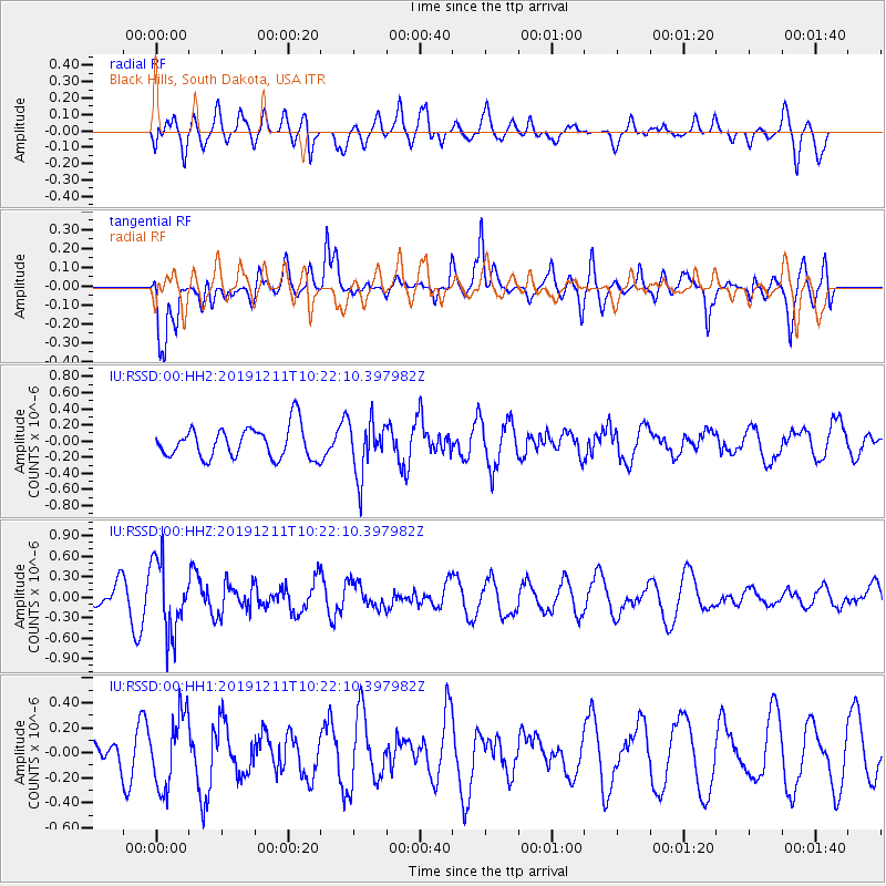
RSSD Black Hills, South Dakota, USA - Earthquake Result Viewer
*The percent match for this event was below the threshold and hence no stack was calculated.
| Earthquake location: |
Kuril Islands |
| Earthquake latitude/longitude: |
48.9/154.8 |
| Earthquake time(UTC): |
2019/12/11 (345) 10:12:07 GMT |
| Earthquake Depth: |
35 km |
| Earthquake Magnitude: |
5.1 Mww |
| Earthquake Catalog/Contributor: |
NEIC PDE/us |
|
| Network: |
IU Global Seismograph Network (GSN - IRIS/USGS) |
| Station: |
RSSD Black Hills, South Dakota, USA |
| Lat/Lon: |
44.12 N/104.04 W |
| Elevation: |
2090 m |
|
| Distance: |
64.6 deg |
| Az: |
51.463 deg |
| Baz: |
314.193 deg |
| Ray Param: |
$rayparam |
*The percent match for this event was below the threshold and hence was not used in the summary stack. |
|
| Radial Match: |
38.506294 % |
| Radial Bump: |
400 |
| Transverse Match: |
64.81818 % |
| Transverse Bump: |
400 |
| SOD ConfigId: |
20465011 |
| Insert Time: |
2020-01-09 12:22:15.368 +0000 |
| GWidth: |
2.5 |
| Max Bumps: |
400 |
| Tol: |
0.001 |
|
Signal To Noise
| Channel | StoN | STA | LTA |
| IU:RSSD:00:HHZ:20191211T10:22:10.397982Z | 3.086964 | 5.283014E-7 | 1.7113949E-7 |
| IU:RSSD:00:HH1:20191211T10:22:10.397982Z | 2.5152617 | 2.8917995E-7 | 1.1497012E-7 |
| IU:RSSD:00:HH2:20191211T10:22:10.397982Z | 1.7668124 | 3.410245E-7 | 1.930168E-7 |
| Arrivals |
| Ps | |
| PpPs | |
| PsPs/PpSs | |


