You are here: Home > Network List > MN - MEDNET Project Stations List
> Station DIVS Divcibare,Serbia > Earthquake Result Viewer
DIVS Divcibare,Serbia - Earthquake Result Viewer
| Earthquake location: |
Kuril Islands |
| Earthquake latitude/longitude: |
46.0/151.4 |
| Earthquake time(UTC): |
2009/04/18 (108) 19:17:58 GMT |
| Earthquake Depth: |
35 km |
| Earthquake Magnitude: |
6.3 MB, 6.3 MS, 6.6 MW, 6.4 MW |
| Earthquake Catalog/Contributor: |
WHDF/NEIC |
|
| Network: |
MN MEDNET Project |
| Station: |
DIVS Divcibare,Serbia |
| Lat/Lon: |
44.10 N/19.99 E |
| Elevation: |
1000 m |
|
| Distance: |
80.5 deg |
| Az: |
326.793 deg |
| Baz: |
31.987 deg |
| Ray Param: |
0.048186764 |
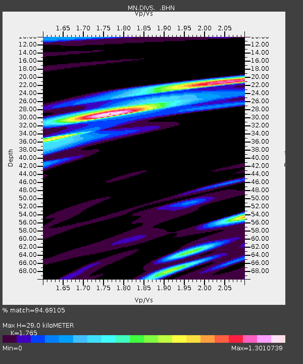
| Estimated Moho Depth: |
29.0 km |
| Estimated Crust Vp/Vs: |
1.76 |
| Assumed Crust Vp: |
6.264 km/s |
| Estimated Crust Vs: |
3.549 km/s |
| Estimated Crust Poisson's Ratio: |
0.26 |
|
| Radial Match: |
94.69105 % |
| Radial Bump: |
400 |
| Transverse Match: |
84.62656 % |
| Transverse Bump: |
400 |
| SOD ConfigId: |
2658 |
| Insert Time: |
2010-03-08 17:01:34.409 +0000 |
| GWidth: |
2.5 |
| Max Bumps: |
400 |
| Tol: |
0.001 |
|

Signal To Noise
| Channel | StoN | STA | LTA |
| MN:DIVS: :BHN:20090418T19:29:36.297004Z | 88.2267 | 3.522819E-6 | 3.9929173E-8 |
| MN:DIVS: :BHE:20090418T19:29:36.297004Z | 34.679832 | 1.1685337E-6 | 3.3694906E-8 |
| MN:DIVS: :BHZ:20090418T19:29:36.297004Z | 8.2019205 | 8.934801E-7 | 1.0893547E-7 |
| Arrivals |
| Ps | 3.6 SECOND |
| PpPs | 12 SECOND |
| PsPs/PpSs | 16 SECOND |


