You are here: Home > Network List > UW - Pacific Northwest Regional Seismic Network Stations List
> Station IRON Crane, OR, USA > Earthquake Result Viewer
IRON Crane, OR, USA - Earthquake Result Viewer
*The percent match for this event was below the threshold and hence no stack was calculated.
| Earthquake location: |
Kuril Islands |
| Earthquake latitude/longitude: |
48.9/154.8 |
| Earthquake time(UTC): |
2019/12/11 (345) 10:12:07 GMT |
| Earthquake Depth: |
35 km |
| Earthquake Magnitude: |
5.1 Mww |
| Earthquake Catalog/Contributor: |
NEIC PDE/us |
|
| Network: |
UW Pacific Northwest Regional Seismic Network |
| Station: |
IRON Crane, OR, USA |
| Lat/Lon: |
43.36 N/118.47 W |
| Elevation: |
1226 m |
|
| Distance: |
57.2 deg |
| Az: |
60.003 deg |
| Baz: |
308.384 deg |
| Ray Param: |
$rayparam |
*The percent match for this event was below the threshold and hence was not used in the summary stack. |
|
| Radial Match: |
75.78264 % |
| Radial Bump: |
362 |
| Transverse Match: |
83.681 % |
| Transverse Bump: |
374 |
| SOD ConfigId: |
20465011 |
| Insert Time: |
2020-01-09 12:30:46.893 +0000 |
| GWidth: |
2.5 |
| Max Bumps: |
400 |
| Tol: |
0.001 |
|
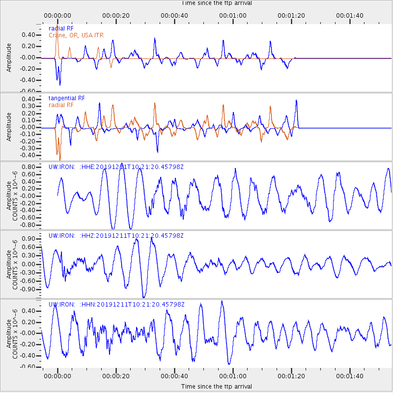
Signal To Noise
| Channel | StoN | STA | LTA |
| UW:IRON: :HHZ:20191211T10:21:20.45798Z | 0.7681523 | 3.459974E-7 | 4.5042813E-7 |
| UW:IRON: :HHN:20191211T10:21:20.45798Z | 2.1619158 | 3.2004854E-7 | 1.4803932E-7 |
| UW:IRON: :HHE:20191211T10:21:20.45798Z | 0.76249707 | 3.425017E-7 | 4.4918426E-7 |
| Arrivals |
| Ps | |
| PpPs | |
| PsPs/PpSs | |


