You are here: Home > Network List > MN - MEDNET Project Stations List
> Station DIVS Divcibare,Serbia > Earthquake Result Viewer
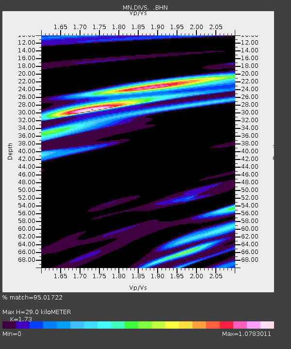
DIVS Divcibare,Serbia - Earthquake Result Viewer
| Earthquake location: |
Kuril Islands |
| Earthquake latitude/longitude: |
46.5/153.2 |
| Earthquake time(UTC): |
2006/10/01 (274) 09:06:02 GMT |
| Earthquake Depth: |
19 km |
| Earthquake Magnitude: |
6.1 MB, 6.4 MS, 6.6 MW, 6.5 MW |
| Earthquake Catalog/Contributor: |
WHDF/NEIC |
|
| Network: |
MN MEDNET Project |
| Station: |
DIVS Divcibare,Serbia |
| Lat/Lon: |
44.10 N/19.99 E |
| Elevation: |
1000 m |
|
| Distance: |
80.8 deg |
| Az: |
327.884 deg |
| Baz: |
30.664 deg |
| Ray Param: |
0.048019297 |
| Estimated Moho Depth: |
29.0 km |
| Estimated Crust Vp/Vs: |
1.73 |
| Assumed Crust Vp: |
6.264 km/s |
| Estimated Crust Vs: |
3.621 km/s |
| Estimated Crust Poisson's Ratio: |
0.25 |
|
| Radial Match: |
95.01722 % |
| Radial Bump: |
400 |
| Transverse Match: |
66.85321 % |
| Transverse Bump: |
400 |
| SOD ConfigId: |
2665 |
| Insert Time: |
2010-03-08 17:02:06.219 +0000 |
| GWidth: |
2.5 |
| Max Bumps: |
400 |
| Tol: |
0.001 |
|

Signal To Noise
| Channel | StoN | STA | LTA |
| MN:DIVS: :BHN:20061001T09:17:43.236016Z | 6.559827 | 5.8926435E-7 | 8.982925E-8 |
| MN:DIVS: :BHE:20061001T09:17:43.236016Z | 1.8532668 | 3.3275276E-7 | 1.7954929E-7 |
| MN:DIVS: :BHZ:20061001T09:17:43.236016Z | 28.900764 | 1.488767E-6 | 5.151307E-8 |
| Arrivals |
| Ps | 3.5 SECOND |
| PpPs | 12 SECOND |
| PsPs/PpSs | 16 SECOND |


