You are here: Home > Network List > US - United States National Seismic Network Stations List
> Station ERPA Erie, Pennsylvania, USA > Earthquake Result Viewer
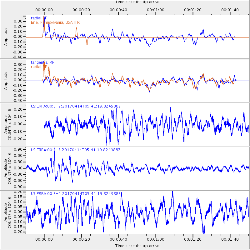
ERPA Erie, Pennsylvania, USA - Earthquake Result Viewer
*The percent match for this event was below the threshold and hence no stack was calculated.
| Earthquake location: |
Southern Mid-Atlantic Ridge |
| Earthquake latitude/longitude: |
-12.4/-14.8 |
| Earthquake time(UTC): |
2017/04/14 (104) 05:29:38 GMT |
| Earthquake Depth: |
10 km |
| Earthquake Magnitude: |
5.5 mb |
| Earthquake Catalog/Contributor: |
NEIC PDE/us |
|
| Network: |
US United States National Seismic Network |
| Station: |
ERPA Erie, Pennsylvania, USA |
| Lat/Lon: |
42.12 N/79.99 W |
| Elevation: |
306 m |
|
| Distance: |
80.6 deg |
| Az: |
316.813 deg |
| Baz: |
116.012 deg |
| Ray Param: |
$rayparam |
*The percent match for this event was below the threshold and hence was not used in the summary stack. |
|
| Radial Match: |
56.198666 % |
| Radial Bump: |
400 |
| Transverse Match: |
51.55708 % |
| Transverse Bump: |
400 |
| SOD ConfigId: |
2028011 |
| Insert Time: |
2017-04-28 05:33:38.480 +0000 |
| GWidth: |
2.5 |
| Max Bumps: |
400 |
| Tol: |
0.001 |
|
Signal To Noise
| Channel | StoN | STA | LTA |
| US:ERPA:00:BHZ:20170414T05:41:19.824988Z | 3.2433405 | 1.993087E-7 | 6.145167E-8 |
| US:ERPA:00:BH1:20170414T05:41:19.824988Z | 1.4015017 | 1.0640117E-7 | 7.59194E-8 |
| US:ERPA:00:BH2:20170414T05:41:19.824988Z | 1.5425086 | 9.069327E-8 | 5.8795955E-8 |
| Arrivals |
| Ps | |
| PpPs | |
| PsPs/PpSs | |


