You are here: Home > Network List > US - United States National Seismic Network Stations List
> Station WUAZ Wupatki, Arizona, USA > Earthquake Result Viewer
WUAZ Wupatki, Arizona, USA - Earthquake Result Viewer
*The percent match for this event was below the threshold and hence no stack was calculated.
| Earthquake location: |
Solomon Islands |
| Earthquake latitude/longitude: |
-9.7/159.9 |
| Earthquake time(UTC): |
2020/01/02 (002) 13:41:31 GMT |
| Earthquake Depth: |
32 km |
| Earthquake Magnitude: |
5.5 mb |
| Earthquake Catalog/Contributor: |
NEIC PDE/us |
|
| Network: |
US United States National Seismic Network |
| Station: |
WUAZ Wupatki, Arizona, USA |
| Lat/Lon: |
35.52 N/111.37 W |
| Elevation: |
1592 m |
|
| Distance: |
94.5 deg |
| Az: |
54.893 deg |
| Baz: |
261.416 deg |
| Ray Param: |
$rayparam |
*The percent match for this event was below the threshold and hence was not used in the summary stack. |
|
| Radial Match: |
63.154327 % |
| Radial Bump: |
400 |
| Transverse Match: |
61.98121 % |
| Transverse Bump: |
400 |
| SOD ConfigId: |
20465011 |
| Insert Time: |
2020-01-16 13:50:19.148 +0000 |
| GWidth: |
2.5 |
| Max Bumps: |
400 |
| Tol: |
0.001 |
|
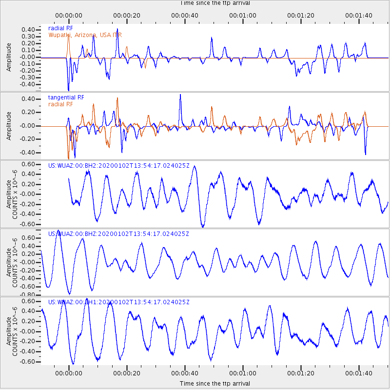
Signal To Noise
| Channel | StoN | STA | LTA |
| US:WUAZ:00:BHZ:20200102T13:54:17.024025Z | 2.0385978 | 4.959989E-7 | 2.4330396E-7 |
| US:WUAZ:00:BH1:20200102T13:54:17.024025Z | 1.4731963 | 3.3532524E-7 | 2.2761749E-7 |
| US:WUAZ:00:BH2:20200102T13:54:17.024025Z | 0.63570243 | 1.7098347E-7 | 2.6896777E-7 |
| Arrivals |
| Ps | |
| PpPs | |
| PsPs/PpSs | |


