You are here: Home > Network List > ET - CERI Southern Appalachian seismic Network Stations List
> Station FPAL Fort Payne,AL > Earthquake Result Viewer
FPAL Fort Payne,AL - Earthquake Result Viewer
| Earthquake location: |
Chile-Argentina Border Region |
| Earthquake latitude/longitude: |
-23.2/-67.7 |
| Earthquake time(UTC): |
2017/04/15 (105) 08:19:41 GMT |
| Earthquake Depth: |
135 km |
| Earthquake Magnitude: |
6.2 Mww |
| Earthquake Catalog/Contributor: |
NEIC PDE/us |
|
| Network: |
ET CERI Southern Appalachian seismic Network |
| Station: |
FPAL Fort Payne,AL |
| Lat/Lon: |
34.54 N/85.61 W |
| Elevation: |
556 m |
|
| Distance: |
59.9 deg |
| Az: |
342.897 deg |
| Baz: |
160.871 deg |
| Ray Param: |
0.061451238 |
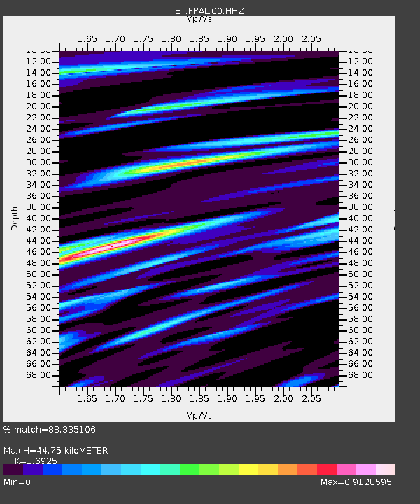
| Estimated Moho Depth: |
44.75 km |
| Estimated Crust Vp/Vs: |
1.69 |
| Assumed Crust Vp: |
6.35 km/s |
| Estimated Crust Vs: |
3.752 km/s |
| Estimated Crust Poisson's Ratio: |
0.23 |
|
| Radial Match: |
88.335106 % |
| Radial Bump: |
400 |
| Transverse Match: |
78.081345 % |
| Transverse Bump: |
400 |
| SOD ConfigId: |
2028011 |
| Insert Time: |
2017-04-29 08:27:39.720 +0000 |
| GWidth: |
2.5 |
| Max Bumps: |
400 |
| Tol: |
0.001 |
|

Signal To Noise
| Channel | StoN | STA | LTA |
| ET:FPAL:00:HHZ:20170415T08:29:03.045017Z | 18.539545 | 2.053084E-6 | 1.107408E-7 |
| ET:FPAL:00:HHN:20170415T08:29:03.045017Z | 11.974302 | 1.0903884E-6 | 9.1060706E-8 |
| ET:FPAL:00:HHE:20170415T08:29:03.045017Z | 2.5108306 | 2.582202E-7 | 1.0284255E-7 |
| Arrivals |
| Ps | 5.1 SECOND |
| PpPs | 18 SECOND |
| PsPs/PpSs | 23 SECOND |


