You are here: Home > Network List > TA - USArray Transportable Network (new EarthScope stations) Stations List
> Station N25K Chitina, Valdez-Cordova, AK, USA > Earthquake Result Viewer
N25K Chitina, Valdez-Cordova, AK, USA - Earthquake Result Viewer
| Earthquake location: |
Near East Coast Of Honshu, Japan |
| Earthquake latitude/longitude: |
35.8/141.1 |
| Earthquake time(UTC): |
2020/01/02 (002) 18:23:51 GMT |
| Earthquake Depth: |
17 km |
| Earthquake Magnitude: |
5.6 Mww |
| Earthquake Catalog/Contributor: |
NEIC PDE/us |
|
| Network: |
TA USArray Transportable Network (new EarthScope stations) |
| Station: |
N25K Chitina, Valdez-Cordova, AK, USA |
| Lat/Lon: |
61.61 N/144.60 W |
| Elevation: |
1087 m |
|
| Distance: |
51.9 deg |
| Az: |
35.775 deg |
| Baz: |
276.186 deg |
| Ray Param: |
0.06709 |
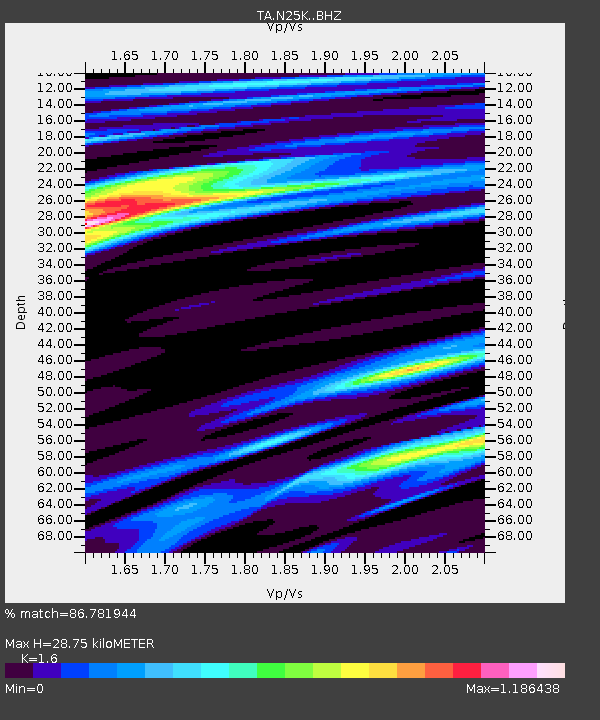
| Estimated Moho Depth: |
28.75 km |
| Estimated Crust Vp/Vs: |
1.60 |
| Assumed Crust Vp: |
6.566 km/s |
| Estimated Crust Vs: |
4.104 km/s |
| Estimated Crust Poisson's Ratio: |
0.18 |
|
| Radial Match: |
86.781944 % |
| Radial Bump: |
400 |
| Transverse Match: |
69.32861 % |
| Transverse Bump: |
400 |
| SOD ConfigId: |
20465011 |
| Insert Time: |
2020-01-16 18:37:40.585 +0000 |
| GWidth: |
2.5 |
| Max Bumps: |
400 |
| Tol: |
0.001 |
|
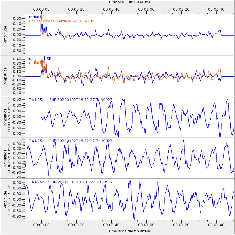
Signal To Noise
| Channel | StoN | STA | LTA |
| TA:N25K: :BHZ:20200102T18:32:27.749992Z | 1.3716103 | 6.163836E-7 | 4.4938682E-7 |
| TA:N25K: :BHN:20200102T18:32:27.749992Z | 1.0955534 | 4.0169817E-7 | 3.666623E-7 |
| TA:N25K: :BHE:20200102T18:32:27.749992Z | 2.8237386 | 6.2913995E-7 | 2.228039E-7 |
| Arrivals |
| Ps | 2.8 SECOND |
| PpPs | 11 SECOND |
| PsPs/PpSs | 13 SECOND |


