You are here: Home > Network List > CN - Canadian National Seismograph Network Stations List
> Station INK INUVIK, NT > Earthquake Result Viewer
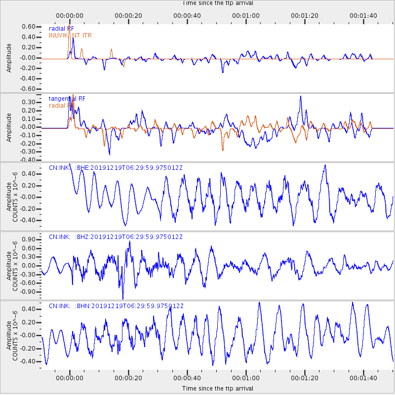
INK INUVIK, NT - Earthquake Result Viewer
*The percent match for this event was below the threshold and hence no stack was calculated.
| Earthquake location: |
Near East Coast Of Honshu, Japan |
| Earthquake latitude/longitude: |
40.6/142.1 |
| Earthquake time(UTC): |
2019/12/19 (353) 06:21:33 GMT |
| Earthquake Depth: |
51 km |
| Earthquake Magnitude: |
5.1 Mww |
| Earthquake Catalog/Contributor: |
NEIC PDE/us |
|
| Network: |
CN Canadian National Seismograph Network |
| Station: |
INK INUVIK, NT |
| Lat/Lon: |
68.31 N/133.53 W |
| Elevation: |
44 m |
|
| Distance: |
51.0 deg |
| Az: |
28.419 deg |
| Baz: |
282.785 deg |
| Ray Param: |
$rayparam |
*The percent match for this event was below the threshold and hence was not used in the summary stack. |
|
| Radial Match: |
56.17654 % |
| Radial Bump: |
400 |
| Transverse Match: |
39.486126 % |
| Transverse Bump: |
400 |
| SOD ConfigId: |
20465011 |
| Insert Time: |
2020-01-17 08:27:56.783 +0000 |
| GWidth: |
2.5 |
| Max Bumps: |
400 |
| Tol: |
0.001 |
|
Signal To Noise
| Channel | StoN | STA | LTA |
| CN:INK: :BHZ:20191219T06:29:59.975012Z | 0.8644756 | 2.2390348E-7 | 2.59005E-7 |
| CN:INK: :BHN:20191219T06:29:59.975012Z | 0.89425015 | 2.394067E-7 | 2.6771778E-7 |
| CN:INK: :BHE:20191219T06:29:59.975012Z | 0.8188017 | 2.0527034E-7 | 2.5069602E-7 |
| Arrivals |
| Ps | |
| PpPs | |
| PsPs/PpSs | |


