You are here: Home > Network List > UW - Pacific Northwest Regional Seismic Network Stations List
> Station HOOD Mt Hood Meadows, OR CREST BB SMO > Earthquake Result Viewer
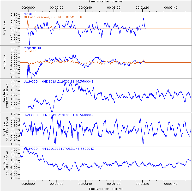
HOOD Mt Hood Meadows, OR CREST BB SMO - Earthquake Result Viewer
*The percent match for this event was below the threshold and hence no stack was calculated.
| Earthquake location: |
Near East Coast Of Honshu, Japan |
| Earthquake latitude/longitude: |
40.6/142.1 |
| Earthquake time(UTC): |
2019/12/19 (353) 06:21:33 GMT |
| Earthquake Depth: |
51 km |
| Earthquake Magnitude: |
5.1 Mww |
| Earthquake Catalog/Contributor: |
NEIC PDE/us |
|
| Network: |
UW Pacific Northwest Regional Seismic Network |
| Station: |
HOOD Mt Hood Meadows, OR CREST BB SMO |
| Lat/Lon: |
45.32 N/121.65 W |
| Elevation: |
1520 m |
|
| Distance: |
66.4 deg |
| Az: |
49.925 deg |
| Baz: |
304.28 deg |
| Ray Param: |
$rayparam |
*The percent match for this event was below the threshold and hence was not used in the summary stack. |
|
| Radial Match: |
59.89008 % |
| Radial Bump: |
400 |
| Transverse Match: |
79.73173 % |
| Transverse Bump: |
400 |
| SOD ConfigId: |
20465011 |
| Insert Time: |
2020-01-17 08:39:27.099 +0000 |
| GWidth: |
2.5 |
| Max Bumps: |
400 |
| Tol: |
0.001 |
|
Signal To Noise
| Channel | StoN | STA | LTA |
| UW:HOOD: :HHZ:20191219T06:31:46.560004Z | 1.2429057 | 3.6024093E-7 | 2.898377E-7 |
| UW:HOOD: :HHN:20191219T06:31:46.560004Z | 2.9831097 | 5.968593E-6 | 2.0007958E-6 |
| UW:HOOD: :HHE:20191219T06:31:46.560004Z | 3.9774888 | 3.7564835E-6 | 9.4443595E-7 |
| Arrivals |
| Ps | |
| PpPs | |
| PsPs/PpSs | |


