You are here: Home > Network List > GS - US Geological Survey Networks Stations List
> Station KAN08 Pence Farm, Harper, KS, USA > Earthquake Result Viewer
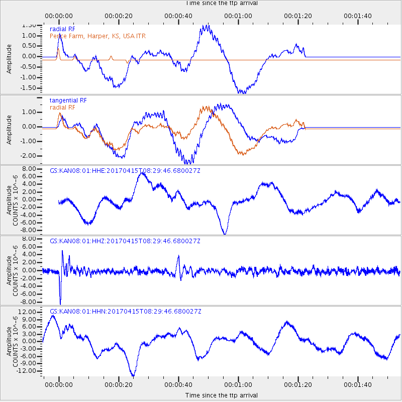
KAN08 Pence Farm, Harper, KS, USA - Earthquake Result Viewer
*The percent match for this event was below the threshold and hence no stack was calculated.
| Earthquake location: |
Chile-Argentina Border Region |
| Earthquake latitude/longitude: |
-23.2/-67.7 |
| Earthquake time(UTC): |
2017/04/15 (105) 08:19:41 GMT |
| Earthquake Depth: |
135 km |
| Earthquake Magnitude: |
6.2 Mww |
| Earthquake Catalog/Contributor: |
NEIC PDE/us |
|
| Network: |
GS US Geological Survey Networks |
| Station: |
KAN08 Pence Farm, Harper, KS, USA |
| Lat/Lon: |
37.23 N/97.97 W |
| Elevation: |
375 m |
|
| Distance: |
66.6 deg |
| Az: |
333.953 deg |
| Baz: |
149.6 deg |
| Ray Param: |
$rayparam |
*The percent match for this event was below the threshold and hence was not used in the summary stack. |
|
| Radial Match: |
42.252075 % |
| Radial Bump: |
400 |
| Transverse Match: |
44.543697 % |
| Transverse Bump: |
400 |
| SOD ConfigId: |
2028011 |
| Insert Time: |
2017-04-29 08:28:54.629 +0000 |
| GWidth: |
2.5 |
| Max Bumps: |
400 |
| Tol: |
0.001 |
|
Signal To Noise
| Channel | StoN | STA | LTA |
| GS:KAN08:01:HHZ:20170415T08:29:46.680027Z | 8.786048 | 2.7112326E-6 | 3.0858388E-7 |
| GS:KAN08:01:HHN:20170415T08:29:46.680027Z | 1.8465632 | 7.193305E-6 | 3.8955095E-6 |
| GS:KAN08:01:HHE:20170415T08:29:46.680027Z | 2.852094 | 5.926111E-6 | 2.0778107E-6 |
| Arrivals |
| Ps | |
| PpPs | |
| PsPs/PpSs | |


