You are here: Home > Network List > MN - MEDNET Project Stations List
> Station DIVS Divcibare,Serbia > Earthquake Result Viewer
DIVS Divcibare,Serbia - Earthquake Result Viewer

| Earthquake location: |
Lake Tanganyika Region |
| Earthquake latitude/longitude: |
-6.3/29.7 |
| Earthquake time(UTC): |
2007/03/28 (087) 21:17:10 GMT |
| Earthquake Depth: |
8.0 km |
| Earthquake Magnitude: |
5.8 MB, 5.8 MS, 5.8 MW, 5.7 MW |
| Earthquake Catalog/Contributor: |
WHDF/NEIC |
|
| Network: |
MN MEDNET Project |
| Station: |
DIVS Divcibare,Serbia |
| Lat/Lon: |
44.10 N/19.99 E |
| Elevation: |
1000 m |
|
| Distance: |
50.9 deg |
| Az: |
351.016 deg |
| Baz: |
167.558 deg |
| Ray Param: |
0.067761496 |
| Estimated Moho Depth: |
31.25 km |
| Estimated Crust Vp/Vs: |
1.76 |
| Assumed Crust Vp: |
6.264 km/s |
| Estimated Crust Vs: |
3.559 km/s |
| Estimated Crust Poisson's Ratio: |
0.26 |
|
| Radial Match: |
93.86961 % |
| Radial Bump: |
400 |
| Transverse Match: |
81.25213 % |
| Transverse Bump: |
400 |
| SOD ConfigId: |
2564 |
| Insert Time: |
2010-03-08 17:05:19.526 +0000 |
| GWidth: |
2.5 |
| Max Bumps: |
400 |
| Tol: |
0.001 |
|
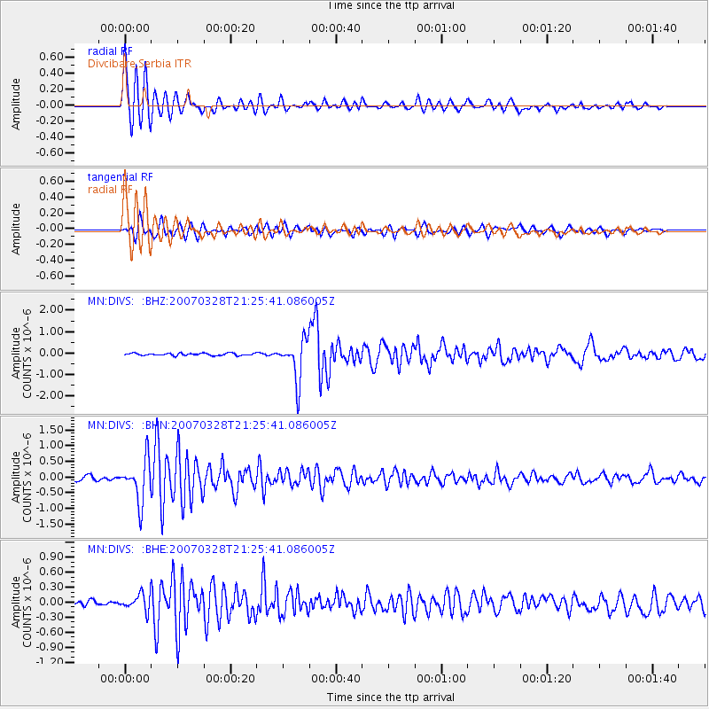
Signal To Noise
| Channel | StoN | STA | LTA |
| MN:DIVS: :BHN:20070328T21:25:41.086005Z | 12.389624 | 6.806104E-7 | 5.493391E-8 |
| MN:DIVS: :BHE:20070328T21:25:41.086005Z | 2.3615818 | 1.7688036E-7 | 7.48991E-8 |
| MN:DIVS: :BHZ:20070328T21:25:41.086005Z | 19.21336 | 9.764096E-7 | 5.081931E-8 |
| Arrivals |
| Ps | 4.0 SECOND |
| PpPs | 13 SECOND |
| PsPs/PpSs | 17 SECOND |


