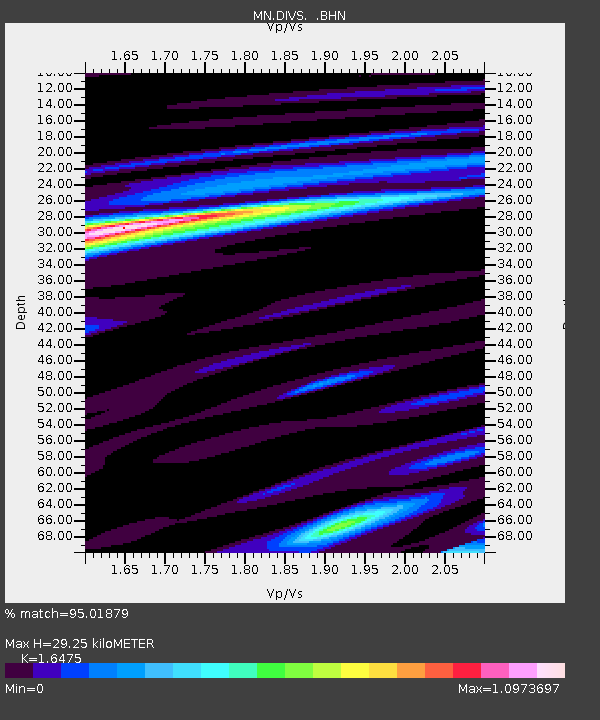
DIVS Divcibare,Serbia - Earthquake Result Viewer
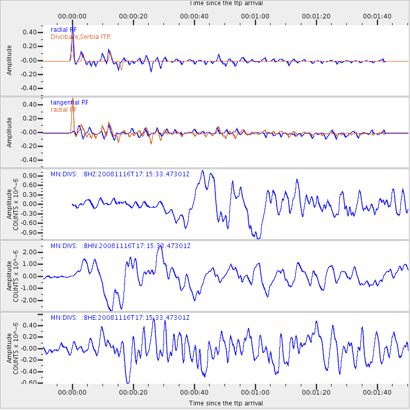
Earthquake location: Minahassa Peninsula, Sulawesi
Earthquake latitude/longitude: 1.3/122.1
Earthquake time(UTC): 2008/11/16 (321) 17:02:32 GMT
Earthquake Depth: 30 km
Earthquake Magnitude: 6.5 MB, 7.0 MS, 7.3 MW, 7.3 MW
Earthquake Catalog/Contributor: WHDF/NEIC
Network: MN MEDNET Project
Station: DIVS Divcibare,Serbia
Lat/Lon: 44.10 N/19.99 E
Elevation: 1000 m
Distance: 97.8 deg
Az: 314.679 deg
Baz: 80.636 deg
Ray Param: 0.04008999
Estimated Moho Depth: 29.25 km
Estimated Crust Vp/Vs: 1.65
Assumed Crust Vp: 6.264 km/s
Estimated Crust Vs: 3.802 km/s
Estimated Crust Poisson's Ratio: 0.21
Radial Match: 95.01879 %
Radial Bump: 400
Transverse Match: 73.99428 %
Transverse Bump: 400
SOD ConfigId: 2658
Insert Time: 2010-03-08 17:05:27.511 +0000
GWidth: 2.5
Max Bumps: 400
Tol: 0.001

Signal To Noise

ChannelStoNSTALTA
MN:DIVS: :BHN:20081116T17:15:33.47301Z6.4905728.011577E-71.2343408E-7
MN:DIVS: :BHE:20081116T17:15:33.47301Z1.07766261.1834657E-71.0981783E-7
MN:DIVS: :BHZ:20081116T17:15:33.47301Z4.33848333.3303277E-77.676249E-8
Arrivals
Ps3.1 SECOND
PpPs12 SECOND
PsPs/PpSs15 SECOND