You are here: Home > Network List > GS - US Geological Survey Networks Stations List
> Station OK048 Pawnee, OK, Station 48 > Earthquake Result Viewer
OK048 Pawnee, OK, Station 48 - Earthquake Result Viewer
| Earthquake location: |
Chile-Argentina Border Region |
| Earthquake latitude/longitude: |
-23.2/-67.7 |
| Earthquake time(UTC): |
2017/04/15 (105) 08:19:41 GMT |
| Earthquake Depth: |
135 km |
| Earthquake Magnitude: |
6.2 Mww |
| Earthquake Catalog/Contributor: |
NEIC PDE/us |
|
| Network: |
GS US Geological Survey Networks |
| Station: |
OK048 Pawnee, OK, Station 48 |
| Lat/Lon: |
36.42 N/96.94 W |
| Elevation: |
297 m |
|
| Distance: |
65.5 deg |
| Az: |
334.291 deg |
| Baz: |
150.35 deg |
| Ray Param: |
0.057875402 |
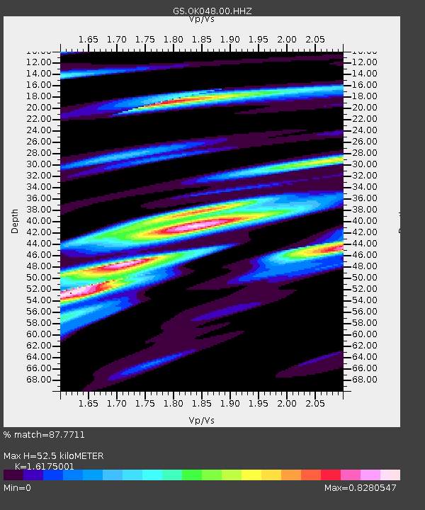
| Estimated Moho Depth: |
52.5 km |
| Estimated Crust Vp/Vs: |
1.62 |
| Assumed Crust Vp: |
6.483 km/s |
| Estimated Crust Vs: |
4.008 km/s |
| Estimated Crust Poisson's Ratio: |
0.19 |
|
| Radial Match: |
87.7711 % |
| Radial Bump: |
400 |
| Transverse Match: |
59.13272 % |
| Transverse Bump: |
400 |
| SOD ConfigId: |
2028011 |
| Insert Time: |
2017-04-29 08:29:32.113 +0000 |
| GWidth: |
2.5 |
| Max Bumps: |
400 |
| Tol: |
0.001 |
|

Signal To Noise
| Channel | StoN | STA | LTA |
| GS:OK048:00:HHZ:20170415T08:29:39.598972Z | 31.704487 | 3.2495707E-6 | 1.02495605E-7 |
| GS:OK048:00:HH1:20170415T08:29:39.598972Z | 7.338436 | 1.1434936E-6 | 1.5582253E-7 |
| GS:OK048:00:HH2:20170415T08:29:39.598972Z | 7.997083 | 8.2867956E-7 | 1.0362273E-7 |
| Arrivals |
| Ps | 5.2 SECOND |
| PpPs | 20 SECOND |
| PsPs/PpSs | 25 SECOND |


