You are here: Home > Network List > GS - US Geological Survey Networks Stations List
> Station ASL9 Albuquerque, New Mexico, USA > Earthquake Result Viewer
ASL9 Albuquerque, New Mexico, USA - Earthquake Result Viewer
| Earthquake location: |
Chile-Argentina Border Region |
| Earthquake latitude/longitude: |
-23.2/-67.7 |
| Earthquake time(UTC): |
2017/04/15 (105) 08:19:41 GMT |
| Earthquake Depth: |
135 km |
| Earthquake Magnitude: |
6.2 Mww |
| Earthquake Catalog/Contributor: |
NEIC PDE/us |
|
| Network: |
GS US Geological Survey Networks |
| Station: |
ASL9 Albuquerque, New Mexico, USA |
| Lat/Lon: |
34.95 N/106.46 W |
| Elevation: |
1820 m |
|
| Distance: |
68.6 deg |
| Az: |
326.427 deg |
| Baz: |
141.742 deg |
| Ray Param: |
0.05584933 |
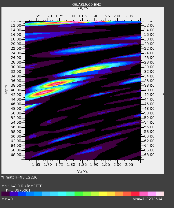
| Estimated Moho Depth: |
10.0 km |
| Estimated Crust Vp/Vs: |
1.87 |
| Assumed Crust Vp: |
6.502 km/s |
| Estimated Crust Vs: |
3.481 km/s |
| Estimated Crust Poisson's Ratio: |
0.30 |
|
| Radial Match: |
93.12286 % |
| Radial Bump: |
400 |
| Transverse Match: |
89.60687 % |
| Transverse Bump: |
400 |
| SOD ConfigId: |
2028011 |
| Insert Time: |
2017-04-29 08:29:40.334 +0000 |
| GWidth: |
2.5 |
| Max Bumps: |
400 |
| Tol: |
0.001 |
|

Signal To Noise
| Channel | StoN | STA | LTA |
| GS:ASL9:00:BHZ:20170415T08:29:59.219028Z | 51.65783 | 2.312643E-6 | 4.4768488E-8 |
| GS:ASL9:00:BH1:20170415T08:29:59.219028Z | 23.309982 | 1.2514266E-6 | 5.36863E-8 |
| GS:ASL9:00:BH2:20170415T08:29:59.219028Z | 11.303049 | 6.422125E-7 | 5.6817633E-8 |
| Arrivals |
| Ps | 1.4 SECOND |
| PpPs | 4.3 SECOND |
| PsPs/PpSs | 5.6 SECOND |


