You are here: Home > Network List > MN - MEDNET Project Stations List
> Station DIVS Divcibare,Serbia > Earthquake Result Viewer
DIVS Divcibare,Serbia - Earthquake Result Viewer
| Earthquake location: |
Sea Of Okhotsk |
| Earthquake latitude/longitude: |
54.2/154.3 |
| Earthquake time(UTC): |
2008/11/24 (329) 09:02:58 GMT |
| Earthquake Depth: |
492 km |
| Earthquake Magnitude: |
6.5 MB, 7.3 MW, 7.3 MW |
| Earthquake Catalog/Contributor: |
WHDF/NEIC |
|
| Network: |
MN MEDNET Project |
| Station: |
DIVS Divcibare,Serbia |
| Lat/Lon: |
44.10 N/19.99 E |
| Elevation: |
1000 m |
|
| Distance: |
74.6 deg |
| Az: |
327.687 deg |
| Baz: |
25.841 deg |
| Ray Param: |
0.05068744 |
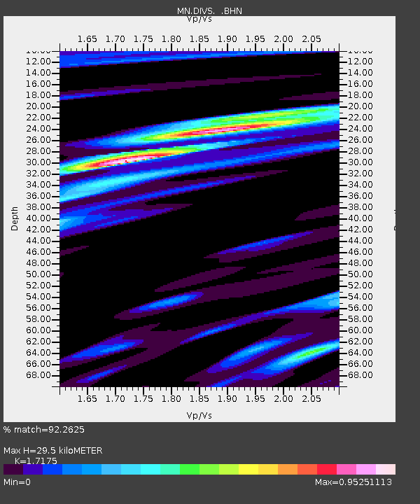
| Estimated Moho Depth: |
29.5 km |
| Estimated Crust Vp/Vs: |
1.72 |
| Assumed Crust Vp: |
6.264 km/s |
| Estimated Crust Vs: |
3.647 km/s |
| Estimated Crust Poisson's Ratio: |
0.24 |
|
| Radial Match: |
92.2625 % |
| Radial Bump: |
400 |
| Transverse Match: |
73.21686 % |
| Transverse Bump: |
400 |
| SOD ConfigId: |
2658 |
| Insert Time: |
2010-03-08 17:05:59.522 +0000 |
| GWidth: |
2.5 |
| Max Bumps: |
400 |
| Tol: |
0.001 |
|

Signal To Noise
| Channel | StoN | STA | LTA |
| MN:DIVS: :BHN:20081124T09:13:15.872Z | 18.066732 | 5.303152E-6 | 2.9353134E-7 |
| MN:DIVS: :BHE:20081124T09:13:15.872Z | 14.93682 | 2.1864464E-6 | 1.4637965E-7 |
| MN:DIVS: :BHZ:20081124T09:13:15.872Z | 8.316384 | 1.4193113E-6 | 1.7066446E-7 |
| Arrivals |
| Ps | 3.5 SECOND |
| PpPs | 12 SECOND |
| PsPs/PpSs | 16 SECOND |


