You are here: Home > Network List > TA - USArray Transportable Network (new EarthScope stations) Stations List
> Station G17K Kiwalik Mountain, AK, USA > Earthquake Result Viewer
G17K Kiwalik Mountain, AK, USA - Earthquake Result Viewer
| Earthquake location: |
Oaxaca, Mexico |
| Earthquake latitude/longitude: |
16.4/-94.3 |
| Earthquake time(UTC): |
2020/01/05 (005) 04:40:50 GMT |
| Earthquake Depth: |
97 km |
| Earthquake Magnitude: |
5.8 Mww |
| Earthquake Catalog/Contributor: |
NEIC PDE/us |
|
| Network: |
TA USArray Transportable Network (new EarthScope stations) |
| Station: |
G17K Kiwalik Mountain, AK, USA |
| Lat/Lon: |
65.50 N/160.65 W |
| Elevation: |
338 m |
|
| Distance: |
65.4 deg |
| Az: |
335.17 deg |
| Baz: |
104.874 deg |
| Ray Param: |
0.058029104 |
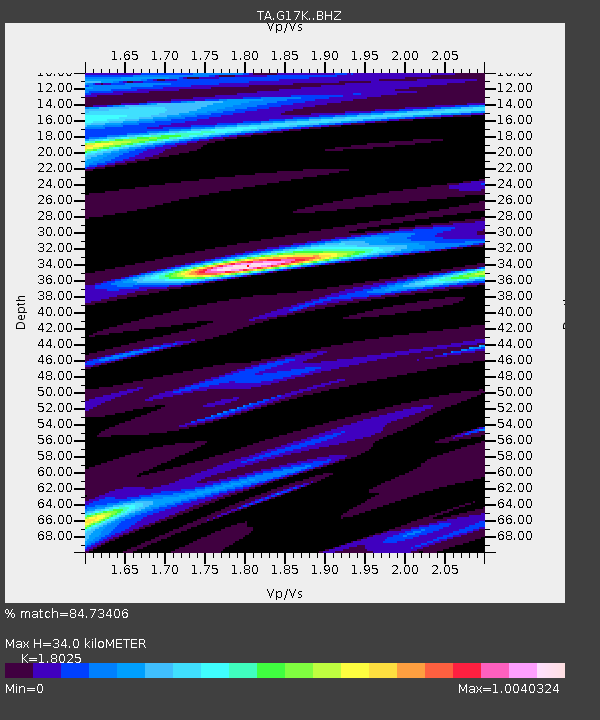
| Estimated Moho Depth: |
34.0 km |
| Estimated Crust Vp/Vs: |
1.80 |
| Assumed Crust Vp: |
6.276 km/s |
| Estimated Crust Vs: |
3.482 km/s |
| Estimated Crust Poisson's Ratio: |
0.28 |
|
| Radial Match: |
84.73406 % |
| Radial Bump: |
400 |
| Transverse Match: |
51.818398 % |
| Transverse Bump: |
352 |
| SOD ConfigId: |
20465011 |
| Insert Time: |
2020-01-19 04:52:02.164 +0000 |
| GWidth: |
2.5 |
| Max Bumps: |
400 |
| Tol: |
0.001 |
|

Signal To Noise
| Channel | StoN | STA | LTA |
| TA:G17K: :BHZ:20200105T04:50:52.249982Z | 2.9561484 | 4.850183E-7 | 1.6407103E-7 |
| TA:G17K: :BHN:20200105T04:50:52.249982Z | 0.92262745 | 9.248867E-8 | 1.0024487E-7 |
| TA:G17K: :BHE:20200105T04:50:52.249982Z | 3.1167097 | 2.7231525E-7 | 8.737267E-8 |
| Arrivals |
| Ps | 4.5 SECOND |
| PpPs | 15 SECOND |
| PsPs/PpSs | 19 SECOND |


