You are here: Home > Network List > NE - New England Seismic Network Stations List
> Station EMMW Machias, ME, USA > Earthquake Result Viewer
EMMW Machias, ME, USA - Earthquake Result Viewer

| Earthquake location: |
Chile-Argentina Border Region |
| Earthquake latitude/longitude: |
-23.2/-67.7 |
| Earthquake time(UTC): |
2017/04/15 (105) 08:19:41 GMT |
| Earthquake Depth: |
135 km |
| Earthquake Magnitude: |
6.2 Mww |
| Earthquake Catalog/Contributor: |
NEIC PDE/us |
|
| Network: |
NE New England Seismic Network |
| Station: |
EMMW Machias, ME, USA |
| Lat/Lon: |
44.71 N/67.46 W |
| Elevation: |
35 m |
|
| Distance: |
67.6 deg |
| Az: |
0.151 deg |
| Baz: |
180.194 deg |
| Ray Param: |
0.056478478 |
| Estimated Moho Depth: |
33.5 km |
| Estimated Crust Vp/Vs: |
1.75 |
| Assumed Crust Vp: |
6.419 km/s |
| Estimated Crust Vs: |
3.663 km/s |
| Estimated Crust Poisson's Ratio: |
0.26 |
|
| Radial Match: |
88.16951 % |
| Radial Bump: |
347 |
| Transverse Match: |
71.48197 % |
| Transverse Bump: |
400 |
| SOD ConfigId: |
2028011 |
| Insert Time: |
2017-04-29 08:31:24.495 +0000 |
| GWidth: |
2.5 |
| Max Bumps: |
400 |
| Tol: |
0.001 |
|
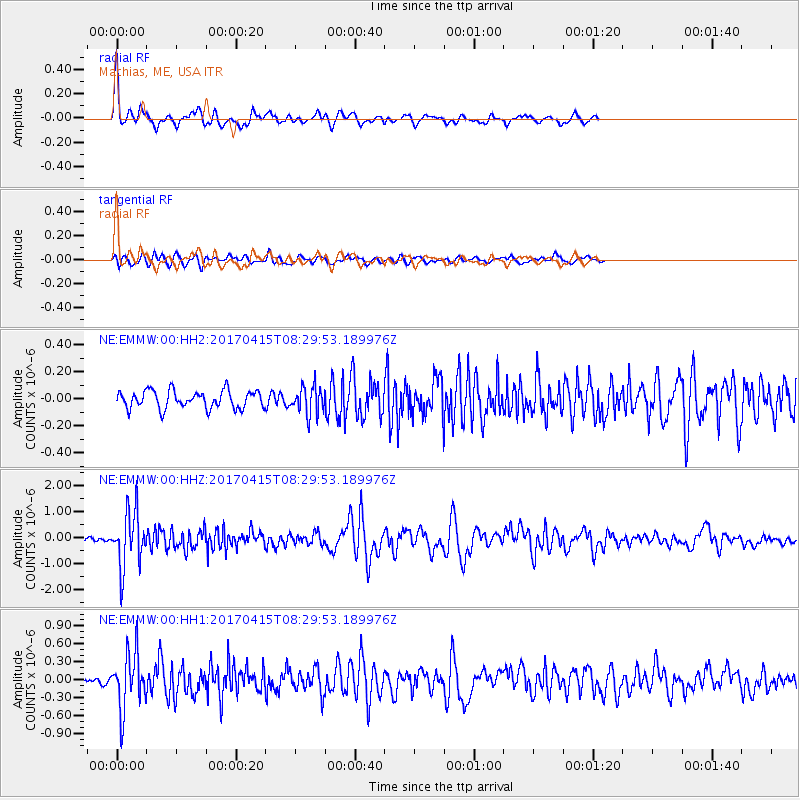
Signal To Noise
| Channel | StoN | STA | LTA |
| NE:EMMW:00:HHZ:20170415T08:29:53.189976Z | 14.089035 | 1.068171E-6 | 7.581576E-8 |
| NE:EMMW:00:HH1:20170415T08:29:53.189976Z | 5.329777 | 4.6909375E-7 | 8.801377E-8 |
| NE:EMMW:00:HH2:20170415T08:29:53.189976Z | 1.575085 | 1.02481906E-7 | 6.506436E-8 |
| Arrivals |
| Ps | 4.1 SECOND |
| PpPs | 14 SECOND |
| PsPs/PpSs | 18 SECOND |


