You are here: Home > Network List > G - GEOSCOPE Stations List
> Station MPG Montagne des Peres, French Guyana > Earthquake Result Viewer
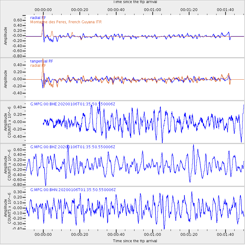
MPG Montagne des Peres, French Guyana - Earthquake Result Viewer
*The percent match for this event was below the threshold and hence no stack was calculated.
| Earthquake location: |
North Of Ascension Island |
| Earthquake latitude/longitude: |
0.2/-17.0 |
| Earthquake time(UTC): |
2020/01/06 (006) 01:29:20 GMT |
| Earthquake Depth: |
10 km |
| Earthquake Magnitude: |
5.6 Mww |
| Earthquake Catalog/Contributor: |
NEIC PDE/us |
|
| Network: |
G GEOSCOPE |
| Station: |
MPG Montagne des Peres, French Guyana |
| Lat/Lon: |
5.11 N/52.64 W |
| Elevation: |
147 m |
|
| Distance: |
35.9 deg |
| Az: |
278.34 deg |
| Baz: |
96.63 deg |
| Ray Param: |
$rayparam |
*The percent match for this event was below the threshold and hence was not used in the summary stack. |
|
| Radial Match: |
61.58771 % |
| Radial Bump: |
400 |
| Transverse Match: |
56.511765 % |
| Transverse Bump: |
400 |
| SOD ConfigId: |
20465011 |
| Insert Time: |
2020-01-20 01:33:09.668 +0000 |
| GWidth: |
2.5 |
| Max Bumps: |
400 |
| Tol: |
0.001 |
|
Signal To Noise
| Channel | StoN | STA | LTA |
| G:MPG:00:BHZ:20200106T01:35:50.550006Z | 1.6980383 | 3.4889646E-7 | 2.0547031E-7 |
| G:MPG:00:BHN:20200106T01:35:50.550006Z | 0.91623646 | 1.0815445E-7 | 1.1804208E-7 |
| G:MPG:00:BHE:20200106T01:35:50.550006Z | 2.859465 | 2.840619E-7 | 9.934094E-8 |
| Arrivals |
| Ps | |
| PpPs | |
| PsPs/PpSs | |


