You are here: Home > Network List > NE - New England Seismic Network Stations List
> Station WSPT Westport, CT, USA > Earthquake Result Viewer
WSPT Westport, CT, USA - Earthquake Result Viewer
| Earthquake location: |
Chile-Argentina Border Region |
| Earthquake latitude/longitude: |
-23.2/-67.7 |
| Earthquake time(UTC): |
2017/04/15 (105) 08:19:41 GMT |
| Earthquake Depth: |
135 km |
| Earthquake Magnitude: |
6.2 Mww |
| Earthquake Catalog/Contributor: |
NEIC PDE/us |
|
| Network: |
NE New England Seismic Network |
| Station: |
WSPT Westport, CT, USA |
| Lat/Lon: |
41.17 N/73.33 W |
| Elevation: |
91 m |
|
| Distance: |
64.3 deg |
| Az: |
355.247 deg |
| Baz: |
174.206 deg |
| Ray Param: |
0.058638304 |
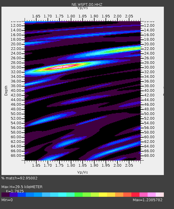
| Estimated Moho Depth: |
29.5 km |
| Estimated Crust Vp/Vs: |
1.76 |
| Assumed Crust Vp: |
6.472 km/s |
| Estimated Crust Vs: |
3.672 km/s |
| Estimated Crust Poisson's Ratio: |
0.26 |
|
| Radial Match: |
92.95882 % |
| Radial Bump: |
266 |
| Transverse Match: |
80.91329 % |
| Transverse Bump: |
369 |
| SOD ConfigId: |
2028011 |
| Insert Time: |
2017-04-29 08:31:36.949 +0000 |
| GWidth: |
2.5 |
| Max Bumps: |
400 |
| Tol: |
0.001 |
|

Signal To Noise
| Channel | StoN | STA | LTA |
| NE:WSPT:00:HHZ:20170415T08:29:32.024021Z | 17.013332 | 1.2956447E-6 | 7.615466E-8 |
| NE:WSPT:00:HH1:20170415T08:29:32.024021Z | 5.9703064 | 5.934887E-7 | 9.940674E-8 |
| NE:WSPT:00:HH2:20170415T08:29:32.024021Z | 3.862115 | 2.72785E-7 | 7.063099E-8 |
| Arrivals |
| Ps | 3.6 SECOND |
| PpPs | 12 SECOND |
| PsPs/PpSs | 16 SECOND |


