You are here: Home > Network List > US - United States National Seismic Network Stations List
> Station AMTX Amarillo, Texas, USA > Earthquake Result Viewer
AMTX Amarillo, Texas, USA - Earthquake Result Viewer
*The percent match for this event was below the threshold and hence no stack was calculated.
| Earthquake location: |
Chile-Argentina Border Region |
| Earthquake latitude/longitude: |
-23.2/-67.7 |
| Earthquake time(UTC): |
2017/04/15 (105) 08:19:41 GMT |
| Earthquake Depth: |
135 km |
| Earthquake Magnitude: |
6.2 Mww |
| Earthquake Catalog/Contributor: |
NEIC PDE/us |
|
| Network: |
US United States National Seismic Network |
| Station: |
AMTX Amarillo, Texas, USA |
| Lat/Lon: |
34.53 N/101.41 W |
| Elevation: |
1010 m |
|
| Distance: |
65.8 deg |
| Az: |
329.803 deg |
| Baz: |
145.917 deg |
| Ray Param: |
$rayparam |
*The percent match for this event was below the threshold and hence was not used in the summary stack. |
|
| Radial Match: |
62.019352 % |
| Radial Bump: |
400 |
| Transverse Match: |
62.315254 % |
| Transverse Bump: |
400 |
| SOD ConfigId: |
2028011 |
| Insert Time: |
2017-04-29 08:32:57.503 +0000 |
| GWidth: |
2.5 |
| Max Bumps: |
400 |
| Tol: |
0.001 |
|
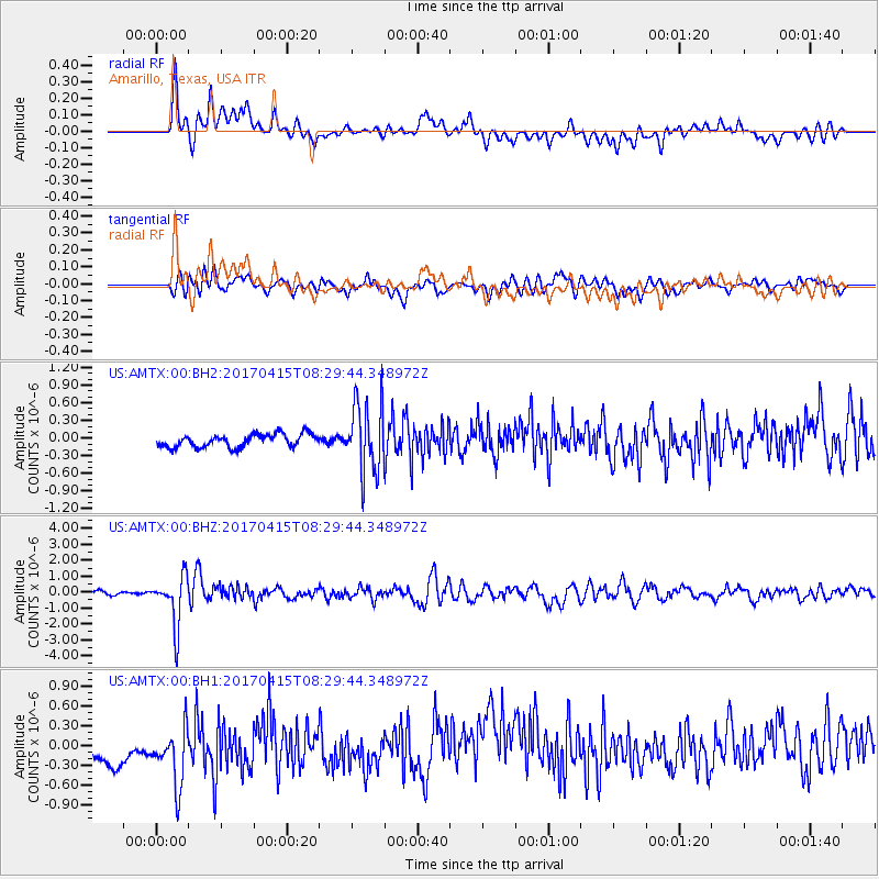
Signal To Noise
| Channel | StoN | STA | LTA |
| US:AMTX:00:BHZ:20170415T08:29:44.348972Z | 15.987616 | 1.5603831E-6 | 9.759949E-8 |
| US:AMTX:00:BH1:20170415T08:29:44.348972Z | 1.860788 | 5.2401117E-7 | 2.8160713E-7 |
| US:AMTX:00:BH2:20170415T08:29:44.348972Z | 4.488818 | 4.6308995E-7 | 1.0316523E-7 |
| Arrivals |
| Ps | |
| PpPs | |
| PsPs/PpSs | |


