You are here: Home > Network List > II - Global Seismograph Network (GSN - IRIS/IDA) Stations List
> Station ABPO Ambohimpanompo, Madagascar > Earthquake Result Viewer
ABPO Ambohimpanompo, Madagascar - Earthquake Result Viewer
| Earthquake location: |
Northern Sumatra, Indonesia |
| Earthquake latitude/longitude: |
2.3/96.3 |
| Earthquake time(UTC): |
2020/01/07 (007) 06:05:20 GMT |
| Earthquake Depth: |
20 km |
| Earthquake Magnitude: |
6.2 Mww |
| Earthquake Catalog/Contributor: |
NEIC PDE/us |
|
| Network: |
II Global Seismograph Network (GSN - IRIS/IDA) |
| Station: |
ABPO Ambohimpanompo, Madagascar |
| Lat/Lon: |
19.02 S/47.23 E |
| Elevation: |
1528 m |
|
| Distance: |
52.7 deg |
| Az: |
244.012 deg |
| Baz: |
71.683 deg |
| Ray Param: |
0.06654955 |
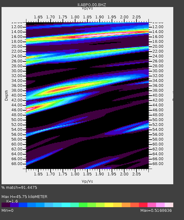
| Estimated Moho Depth: |
45.75 km |
| Estimated Crust Vp/Vs: |
1.60 |
| Assumed Crust Vp: |
6.642 km/s |
| Estimated Crust Vs: |
4.151 km/s |
| Estimated Crust Poisson's Ratio: |
0.18 |
|
| Radial Match: |
91.4475 % |
| Radial Bump: |
298 |
| Transverse Match: |
70.145905 % |
| Transverse Bump: |
400 |
| SOD ConfigId: |
20465011 |
| Insert Time: |
2020-01-21 06:08:35.050 +0000 |
| GWidth: |
2.5 |
| Max Bumps: |
400 |
| Tol: |
0.001 |
|
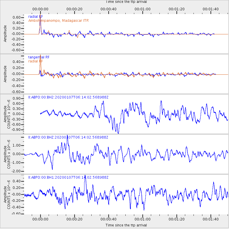
Signal To Noise
| Channel | StoN | STA | LTA |
| II:ABPO:00:BHZ:20200107T06:14:02.568988Z | 3.0203016 | 5.025735E-7 | 1.6639845E-7 |
| II:ABPO:00:BH1:20200107T06:14:02.568988Z | 1.1444108 | 8.3954674E-8 | 7.33606E-8 |
| II:ABPO:00:BH2:20200107T06:14:02.568988Z | 1.8594269 | 1.9552603E-7 | 1.0515392E-7 |
| Arrivals |
| Ps | 4.4 SECOND |
| PpPs | 17 SECOND |
| PsPs/PpSs | 21 SECOND |


