You are here: Home > Network List > TA - USArray Transportable Network (new EarthScope stations) Stations List
> Station C16K Lisburne Hills, AK, USA > Earthquake Result Viewer
C16K Lisburne Hills, AK, USA - Earthquake Result Viewer
*The percent match for this event was below the threshold and hence no stack was calculated.
| Earthquake location: |
Northern Sumatra, Indonesia |
| Earthquake latitude/longitude: |
2.3/96.3 |
| Earthquake time(UTC): |
2020/01/07 (007) 06:05:20 GMT |
| Earthquake Depth: |
20 km |
| Earthquake Magnitude: |
6.2 Mww |
| Earthquake Catalog/Contributor: |
NEIC PDE/us |
|
| Network: |
TA USArray Transportable Network (new EarthScope stations) |
| Station: |
C16K Lisburne Hills, AK, USA |
| Lat/Lon: |
68.27 N/165.34 W |
| Elevation: |
102 m |
|
| Distance: |
90.9 deg |
| Az: |
21.62 deg |
| Baz: |
278.575 deg |
| Ray Param: |
$rayparam |
*The percent match for this event was below the threshold and hence was not used in the summary stack. |
|
| Radial Match: |
78.88649 % |
| Radial Bump: |
400 |
| Transverse Match: |
72.94425 % |
| Transverse Bump: |
400 |
| SOD ConfigId: |
20465011 |
| Insert Time: |
2020-01-21 06:11:09.866 +0000 |
| GWidth: |
2.5 |
| Max Bumps: |
400 |
| Tol: |
0.001 |
|
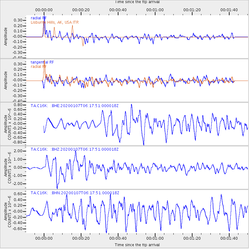
Signal To Noise
| Channel | StoN | STA | LTA |
| TA:C16K: :BHZ:20200107T06:17:51.000018Z | 4.1679134 | 6.959475E-7 | 1.6697744E-7 |
| TA:C16K: :BHN:20200107T06:17:51.000018Z | 1.6762834 | 1.9203974E-7 | 1.14562816E-7 |
| TA:C16K: :BHE:20200107T06:17:51.000018Z | 2.2956355 | 3.0706406E-7 | 1.3375994E-7 |
| Arrivals |
| Ps | |
| PpPs | |
| PsPs/PpSs | |


