You are here: Home > Network List > TA - USArray Transportable Network (new EarthScope stations) Stations List
> Station D17K Noatak River, AK, USA > Earthquake Result Viewer
D17K Noatak River, AK, USA - Earthquake Result Viewer
| Earthquake location: |
Northern Sumatra, Indonesia |
| Earthquake latitude/longitude: |
2.3/96.3 |
| Earthquake time(UTC): |
2020/01/07 (007) 06:05:20 GMT |
| Earthquake Depth: |
20 km |
| Earthquake Magnitude: |
6.2 Mww |
| Earthquake Catalog/Contributor: |
NEIC PDE/us |
|
| Network: |
TA USArray Transportable Network (new EarthScope stations) |
| Station: |
D17K Noatak River, AK, USA |
| Lat/Lon: |
67.70 N/163.08 W |
| Elevation: |
172 m |
|
| Distance: |
91.9 deg |
| Az: |
22.048 deg |
| Baz: |
280.658 deg |
| Ray Param: |
0.041545834 |
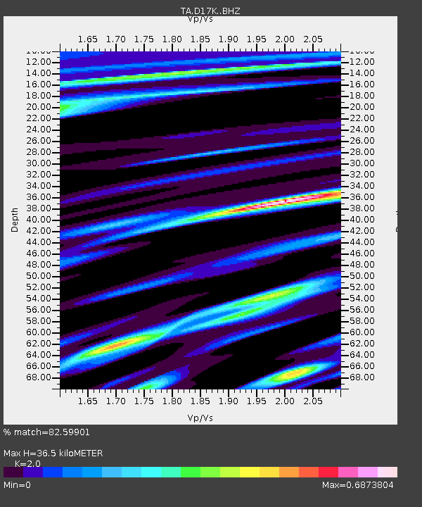
| Estimated Moho Depth: |
36.5 km |
| Estimated Crust Vp/Vs: |
2.00 |
| Assumed Crust Vp: |
6.276 km/s |
| Estimated Crust Vs: |
3.138 km/s |
| Estimated Crust Poisson's Ratio: |
0.33 |
|
| Radial Match: |
82.59901 % |
| Radial Bump: |
400 |
| Transverse Match: |
55.7699 % |
| Transverse Bump: |
400 |
| SOD ConfigId: |
20465011 |
| Insert Time: |
2020-01-21 06:11:19.388 +0000 |
| GWidth: |
2.5 |
| Max Bumps: |
400 |
| Tol: |
0.001 |
|

Signal To Noise
| Channel | StoN | STA | LTA |
| TA:D17K: :BHZ:20200107T06:17:55.32503Z | 7.165392 | 6.1182124E-7 | 8.5385594E-8 |
| TA:D17K: :BHN:20200107T06:17:55.32503Z | 0.8921405 | 1.0688806E-7 | 1.1981079E-7 |
| TA:D17K: :BHE:20200107T06:17:55.32503Z | 1.7404482 | 2.9514356E-7 | 1.6957905E-7 |
| Arrivals |
| Ps | 5.9 SECOND |
| PpPs | 17 SECOND |
| PsPs/PpSs | 23 SECOND |


