You are here: Home > Network List > MN - MEDNET Project Stations List
> Station IDI Anogia, Greece > Earthquake Result Viewer
IDI Anogia, Greece - Earthquake Result Viewer
| Earthquake location: |
Luzon, Philippines |
| Earthquake latitude/longitude: |
14.7/120.0 |
| Earthquake time(UTC): |
1998/08/23 (235) 05:36:12 GMT |
| Earthquake Depth: |
70 km |
| Earthquake Magnitude: |
6.1 MB, 6.1 UNKNOWN, 6.0 MW |
| Earthquake Catalog/Contributor: |
WHDF/NEIC |
|
| Network: |
MN MEDNET Project |
| Station: |
IDI Anogia, Greece |
| Lat/Lon: |
35.29 N/24.89 E |
| Elevation: |
750 m |
|
| Distance: |
85.8 deg |
| Az: |
305.214 deg |
| Baz: |
75.11 deg |
| Ray Param: |
0.04439646 |
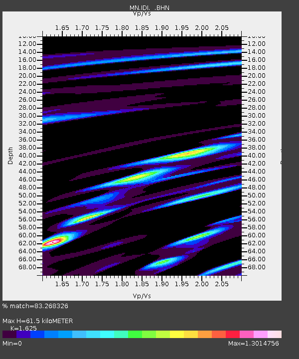
| Estimated Moho Depth: |
61.5 km |
| Estimated Crust Vp/Vs: |
1.62 |
| Assumed Crust Vp: |
5.627 km/s |
| Estimated Crust Vs: |
3.463 km/s |
| Estimated Crust Poisson's Ratio: |
0.20 |
|
| Radial Match: |
83.268326 % |
| Radial Bump: |
400 |
| Transverse Match: |
84.00316 % |
| Transverse Bump: |
400 |
| SOD ConfigId: |
4480 |
| Insert Time: |
2010-03-08 17:08:05.528 +0000 |
| GWidth: |
2.5 |
| Max Bumps: |
400 |
| Tol: |
0.001 |
|
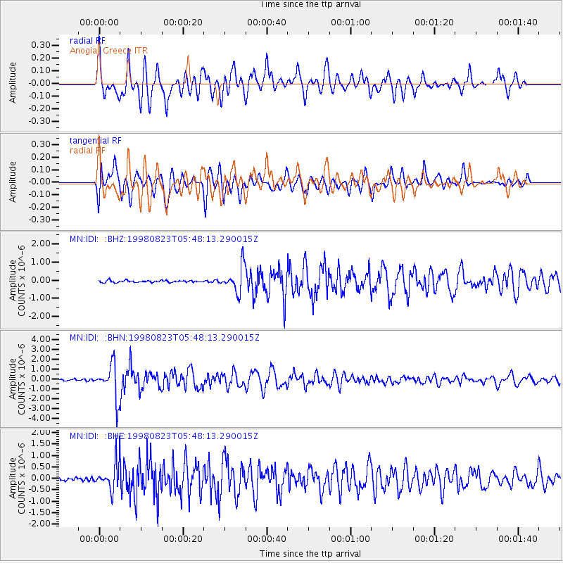
Signal To Noise
| Channel | StoN | STA | LTA |
| MN:IDI: :BHN:19980823T05:48:13.290015Z | 25.43635 | 1.7578856E-6 | 6.910919E-8 |
| MN:IDI: :BHE:19980823T05:48:13.290015Z | 8.446278 | 6.1811227E-7 | 7.3181624E-8 |
| MN:IDI: :BHZ:19980823T05:48:13.290015Z | 14.156023 | 7.3188545E-7 | 5.1701345E-8 |
| Arrivals |
| Ps | 7.0 SECOND |
| PpPs | 28 SECOND |
| PsPs/PpSs | 35 SECOND |


