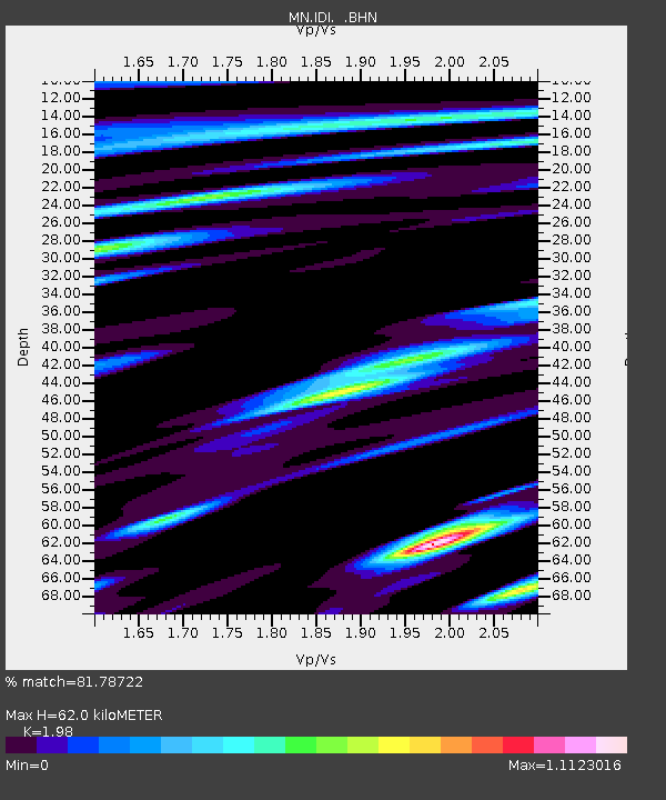
IDI Anogia, Greece - Earthquake Result Viewer
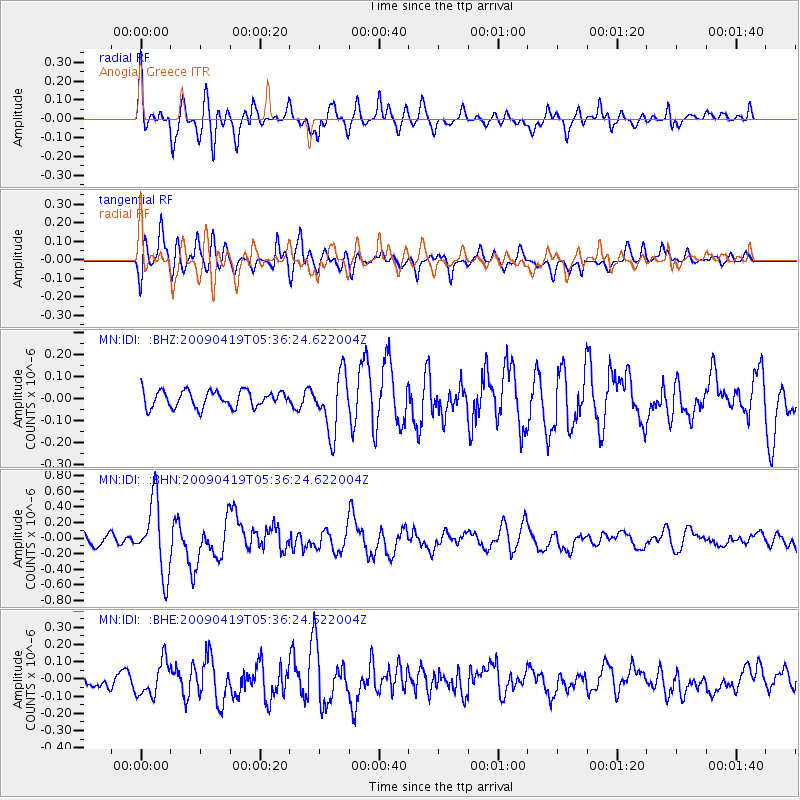
Earthquake location: Talaud Islands, Indonesia
Earthquake latitude/longitude: 4.1/126.7
Earthquake time(UTC): 2009/04/19 (109) 05:23:25 GMT
Earthquake Depth: 25 km
Earthquake Magnitude: 5.9 MB, 5.9 MS, 6.1 MW, 6.1 MW
Earthquake Catalog/Contributor: WHDF/NEIC
Network: MN MEDNET Project
Station: IDI Anogia, Greece
Lat/Lon: 35.29 N/24.89 E
Elevation: 750 m
Distance: 97.2 deg
Az: 306.176 deg
Baz: 79.793 deg
Ray Param: 0.04027295
Estimated Moho Depth: 62.0 km
Estimated Crust Vp/Vs: 1.98
Assumed Crust Vp: 5.627 km/s
Estimated Crust Vs: 2.842 km/s
Estimated Crust Poisson's Ratio: 0.33
Radial Match: 81.78722 %
Radial Bump: 400
Transverse Match: 73.7426 %
Transverse Bump: 400
SOD ConfigId: 2658
Insert Time: 2010-03-08 17:08:06.980 +0000
GWidth: 2.5
Max Bumps: 400
Tol: 0.001

Signal To Noise

ChannelStoNSTALTA
MN:IDI: :BHN:20090419T05:36:24.622004Z7.77428634.6154508E-75.9368162E-8
MN:IDI: :BHE:20090419T05:36:24.622004Z2.4311491.0081699E-74.1468862E-8
MN:IDI: :BHZ:20090419T05:36:24.622004Z3.49858261.3101038E-73.7446704E-8
Arrivals
Ps11 SECOND
PpPs32 SECOND
PsPs/PpSs43 SECOND