You are here: Home > Network List > MN - MEDNET Project Stations List
> Station IDI Anogia, Greece > Earthquake Result Viewer
IDI Anogia, Greece - Earthquake Result Viewer
| Earthquake location: |
Java, Indonesia |
| Earthquake latitude/longitude: |
-8.2/112.4 |
| Earthquake time(UTC): |
1998/09/28 (271) 13:34:30 GMT |
| Earthquake Depth: |
152 km |
| Earthquake Magnitude: |
6.4 MB, 6.5 UNKNOWN, 6.5 MW |
| Earthquake Catalog/Contributor: |
WHDF/NEIC |
|
| Network: |
MN MEDNET Project |
| Station: |
IDI Anogia, Greece |
| Lat/Lon: |
35.29 N/24.89 E |
| Elevation: |
750 m |
|
| Distance: |
92.7 deg |
| Az: |
305.095 deg |
| Baz: |
98.082 deg |
| Ray Param: |
0.041326582 |
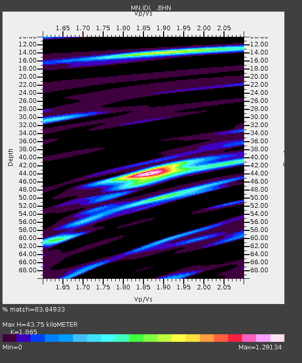
| Estimated Moho Depth: |
43.75 km |
| Estimated Crust Vp/Vs: |
1.87 |
| Assumed Crust Vp: |
5.627 km/s |
| Estimated Crust Vs: |
3.017 km/s |
| Estimated Crust Poisson's Ratio: |
0.30 |
|
| Radial Match: |
83.64933 % |
| Radial Bump: |
400 |
| Transverse Match: |
81.9227 % |
| Transverse Bump: |
400 |
| SOD ConfigId: |
4480 |
| Insert Time: |
2010-03-08 17:08:09.797 +0000 |
| GWidth: |
2.5 |
| Max Bumps: |
400 |
| Tol: |
0.001 |
|
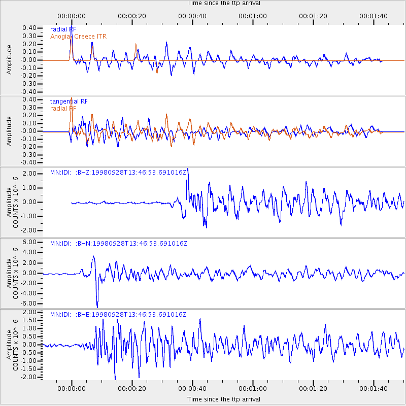
Signal To Noise
| Channel | StoN | STA | LTA |
| MN:IDI: :BHN:19980928T13:46:53.691016Z | 6.8357663 | 3.3368244E-7 | 4.8814194E-8 |
| MN:IDI: :BHE:19980928T13:46:53.691016Z | 1.6947553 | 7.0295975E-8 | 4.1478543E-8 |
| MN:IDI: :BHZ:19980928T13:46:53.691016Z | 3.0105774 | 1.17805314E-7 | 3.913047E-8 |
| Arrivals |
| Ps | 6.8 SECOND |
| PpPs | 22 SECOND |
| PsPs/PpSs | 29 SECOND |


