You are here: Home > Network List > MN - MEDNET Project Stations List
> Station IDI Anogia, Greece > Earthquake Result Viewer
IDI Anogia, Greece - Earthquake Result Viewer
| Earthquake location: |
South Of Java, Indonesia |
| Earthquake latitude/longitude: |
-9.4/108.3 |
| Earthquake time(UTC): |
2006/07/17 (198) 15:45:59 GMT |
| Earthquake Depth: |
21 km |
| Earthquake Magnitude: |
5.9 MB, 5.9 MS, 6.1 MW, 6.1 MW |
| Earthquake Catalog/Contributor: |
WHDF/NEIC |
|
| Network: |
MN MEDNET Project |
| Station: |
IDI Anogia, Greece |
| Lat/Lon: |
35.29 N/24.89 E |
| Elevation: |
750 m |
|
| Distance: |
90.1 deg |
| Az: |
305.639 deg |
| Baz: |
101.418 deg |
| Ray Param: |
0.041698154 |
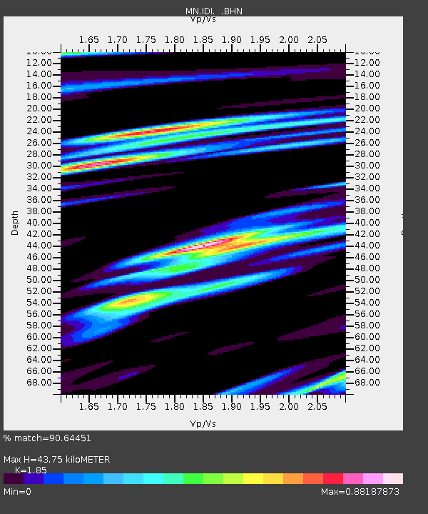
| Estimated Moho Depth: |
43.75 km |
| Estimated Crust Vp/Vs: |
1.85 |
| Assumed Crust Vp: |
5.627 km/s |
| Estimated Crust Vs: |
3.042 km/s |
| Estimated Crust Poisson's Ratio: |
0.29 |
|
| Radial Match: |
90.64451 % |
| Radial Bump: |
400 |
| Transverse Match: |
81.2174 % |
| Transverse Bump: |
400 |
| SOD ConfigId: |
2665 |
| Insert Time: |
2010-03-08 17:08:25.062 +0000 |
| GWidth: |
2.5 |
| Max Bumps: |
400 |
| Tol: |
0.001 |
|

Signal To Noise
| Channel | StoN | STA | LTA |
| MN:IDI: :BHN:20060717T15:58:26.460015Z | 1.1435131 | 1.2231419E-7 | 1.06963526E-7 |
| MN:IDI: :BHE:20060717T15:58:26.460015Z | 1.1343936 | 8.031645E-8 | 7.080122E-8 |
| MN:IDI: :BHZ:20060717T15:58:26.460015Z | 2.1408918 | 2.6877987E-7 | 1.2554575E-7 |
| Arrivals |
| Ps | 6.7 SECOND |
| PpPs | 22 SECOND |
| PsPs/PpSs | 29 SECOND |


