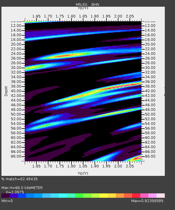
IDI Anogia, Greece - Earthquake Result Viewer

Earthquake location: Northern Sumatra, Indonesia
Earthquake latitude/longitude: 0.1/97.1
Earthquake time(UTC): 2006/05/16 (136) 15:28:25 GMT
Earthquake Depth: 12 km
Earthquake Magnitude: 6.6 MB, 6.8 MS, 6.8 MW, 6.8 MW
Earthquake Catalog/Contributor: WHDF/NEIC
Network: MN MEDNET Project
Station: IDI Anogia, Greece
Lat/Lon: 35.29 N/24.89 E
Elevation: 750 m
Distance: 75.4 deg
Az: 306.426 deg
Baz: 100.409 deg
Ray Param: 0.05167041
Estimated Moho Depth: 68.0 km
Estimated Crust Vp/Vs: 2.10
Assumed Crust Vp: 5.627 km/s
Estimated Crust Vs: 2.683 km/s
Estimated Crust Poisson's Ratio: 0.35
Radial Match: 82.49435 %
Radial Bump: 400
Transverse Match: 79.03188 %
Transverse Bump: 400
SOD ConfigId: 2669
Insert Time: 2010-03-08 17:08:30.051 +0000
GWidth: 2.5
Max Bumps: 400
Tol: 0.001

Signal To Noise

ChannelStoNSTALTA
MN:IDI: :BHN:20060516T15:39:38.211016Z3.13678124.646791E-71.4813882E-7
MN:IDI: :BHE:20060516T15:39:38.211016Z9.0015991.4272648E-61.585568E-7
MN:IDI: :BHZ:20060516T15:39:38.211016Z12.0462823.296082E-62.7361818E-7
Arrivals
Ps14 SECOND
PpPs37 SECOND
PsPs/PpSs50 SECOND