You are here: Home > Network List > MN - MEDNET Project Stations List
> Station IDI Anogia, Greece > Earthquake Result Viewer
IDI Anogia, Greece - Earthquake Result Viewer
| Earthquake location: |
E. Russia-N.E. China Border Reg. |
| Earthquake latitude/longitude: |
43.6/130.4 |
| Earthquake time(UTC): |
1999/04/08 (098) 13:10:34 GMT |
| Earthquake Depth: |
566 km |
| Earthquake Magnitude: |
6.4 MB, 7.1 MW, 7.1 MW |
| Earthquake Catalog/Contributor: |
WHDF/NEIC |
|
| Network: |
MN MEDNET Project |
| Station: |
IDI Anogia, Greece |
| Lat/Lon: |
35.29 N/24.89 E |
| Elevation: |
750 m |
|
| Distance: |
76.3 deg |
| Az: |
305.75 deg |
| Baz: |
46.105 deg |
| Ray Param: |
0.049295004 |
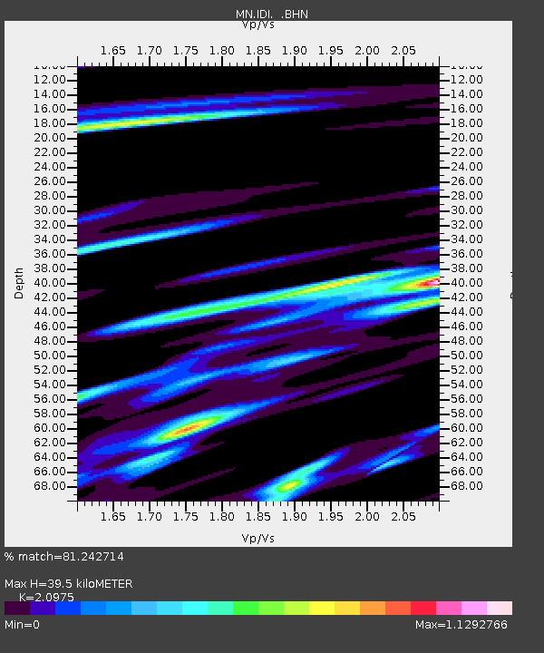
| Estimated Moho Depth: |
39.5 km |
| Estimated Crust Vp/Vs: |
2.10 |
| Assumed Crust Vp: |
5.627 km/s |
| Estimated Crust Vs: |
2.683 km/s |
| Estimated Crust Poisson's Ratio: |
0.35 |
|
| Radial Match: |
81.242714 % |
| Radial Bump: |
400 |
| Transverse Match: |
79.65259 % |
| Transverse Bump: |
400 |
| SOD ConfigId: |
4480 |
| Insert Time: |
2010-03-08 17:08:34.713 +0000 |
| GWidth: |
2.5 |
| Max Bumps: |
400 |
| Tol: |
0.001 |
|

Signal To Noise
| Channel | StoN | STA | LTA |
| MN:IDI: :BHN:19990408T13:20:54.21501Z | 62.142773 | 8.075973E-6 | 1.2995837E-7 |
| MN:IDI: :BHE:19990408T13:20:54.21501Z | 20.651234 | 3.158224E-6 | 1.5293149E-7 |
| MN:IDI: :BHZ:19990408T13:20:54.21501Z | 27.268059 | 2.5776778E-6 | 9.453103E-8 |
| Arrivals |
| Ps | 7.9 SECOND |
| PpPs | 21 SECOND |
| PsPs/PpSs | 29 SECOND |


