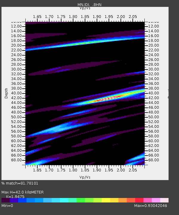
IDI Anogia, Greece - Earthquake Result Viewer

Earthquake location: Andreanof Islands, Aleutian Is.
Earthquake latitude/longitude: 51.2/-179.8
Earthquake time(UTC): 2001/06/14 (165) 19:48:47 GMT
Earthquake Depth: 18 km
Earthquake Magnitude: 6.0 MB, 6.3 MS, 6.5 MW, 6.1 ML
Earthquake Catalog/Contributor: WHDF/NEIC
Network: MN MEDNET Project
Station: IDI Anogia, Greece
Lat/Lon: 35.29 N/24.89 E
Elevation: 750 m
Distance: 91.2 deg
Az: 339.991 deg
Baz: 15.27 deg
Ray Param: 0.041616738
Estimated Moho Depth: 42.0 km
Estimated Crust Vp/Vs: 1.95
Assumed Crust Vp: 5.627 km/s
Estimated Crust Vs: 2.889 km/s
Estimated Crust Poisson's Ratio: 0.32
Radial Match: 81.78101 %
Radial Bump: 400
Transverse Match: 63.328655 %
Transverse Bump: 400
SOD ConfigId: 4714
Insert Time: 2010-03-08 17:08:35.950 +0000
GWidth: 2.5
Max Bumps: 400
Tol: 0.001

Signal To Noise

ChannelStoNSTALTA
MN:IDI: :BHN:20010614T20:01:20.256006Z4.9231962.2439048E-74.5578215E-8
MN:IDI: :BHE:20010614T20:01:20.256006Z1.49800756.3895165E-84.2653433E-8
MN:IDI: :BHZ:20010614T20:01:20.256006Z5.44262273.3314907E-76.1211125E-8
Arrivals
Ps7.2 SECOND
PpPs22 SECOND
PsPs/PpSs29 SECOND