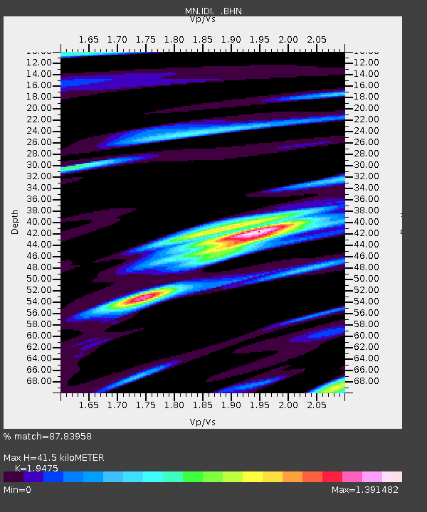
IDI Anogia, Greece - Earthquake Result Viewer
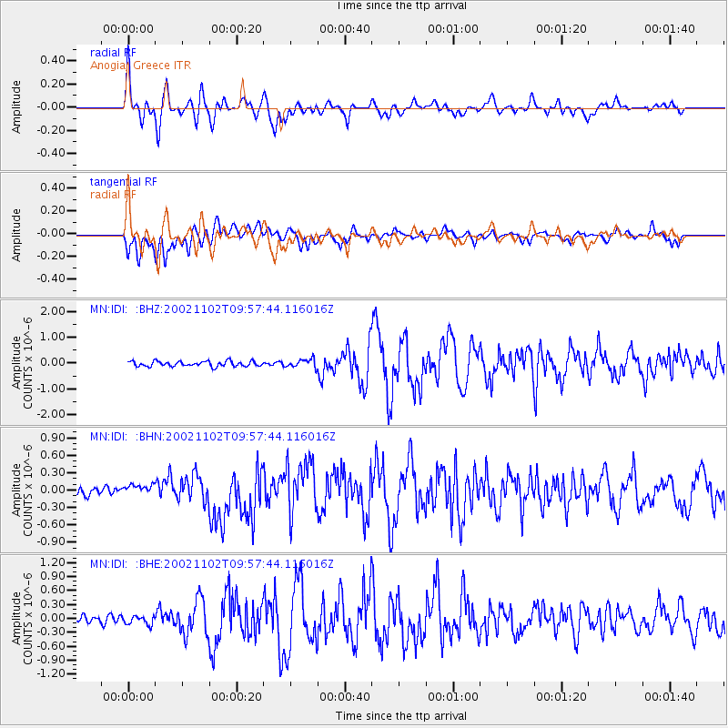
Earthquake location: Northern Sumatra, Indonesia
Earthquake latitude/longitude: 3.0/96.4
Earthquake time(UTC): 2002/11/02 (306) 09:46:46 GMT
Earthquake Depth: 27 km
Earthquake Magnitude: 5.9 MB, 6.4 MS, 6.4 MW, 6.1 MW
Earthquake Catalog/Contributor: WHDF/NEIC
Network: MN MEDNET Project
Station: IDI Anogia, Greece
Lat/Lon: 35.29 N/24.89 E
Elevation: 750 m
Distance: 73.2 deg
Az: 305.874 deg
Baz: 98.428 deg
Ray Param: 0.053110294
Estimated Moho Depth: 41.5 km
Estimated Crust Vp/Vs: 1.95
Assumed Crust Vp: 5.627 km/s
Estimated Crust Vs: 2.889 km/s
Estimated Crust Poisson's Ratio: 0.32
Radial Match: 87.83958 %
Radial Bump: 400
Transverse Match: 74.6675 %
Transverse Bump: 400
SOD ConfigId: 4714
Insert Time: 2010-03-08 17:08:43.486 +0000
GWidth: 2.5
Max Bumps: 400
Tol: 0.001

Signal To Noise

ChannelStoNSTALTA
MN:IDI: :BHN:20021102T09:57:44.116016Z1.15777139.61655E-88.3060876E-8
MN:IDI: :BHE:20021102T09:57:44.116016Z1.32322799.451514E-87.142771E-8
MN:IDI: :BHZ:20021102T09:57:44.116016Z1.69530121.6642146E-79.81663E-8
Arrivals
Ps7.2 SECOND
PpPs21 SECOND
PsPs/PpSs28 SECOND