You are here: Home > Network List > MN - MEDNET Project Stations List
> Station IDI Anogia, Greece > Earthquake Result Viewer
IDI Anogia, Greece - Earthquake Result Viewer
| Earthquake location: |
Kuril Islands |
| Earthquake latitude/longitude: |
46.0/151.5 |
| Earthquake time(UTC): |
2009/04/07 (097) 04:23:33 GMT |
| Earthquake Depth: |
31 km |
| Earthquake Magnitude: |
6.5 MB, 6.8 MS, 6.9 MW, 6.9 MW |
| Earthquake Catalog/Contributor: |
WHDF/NEIC |
|
| Network: |
MN MEDNET Project |
| Station: |
IDI Anogia, Greece |
| Lat/Lon: |
35.29 N/24.89 E |
| Elevation: |
750 m |
|
| Distance: |
85.8 deg |
| Az: |
318.852 deg |
| Baz: |
34.068 deg |
| Ray Param: |
0.044437174 |
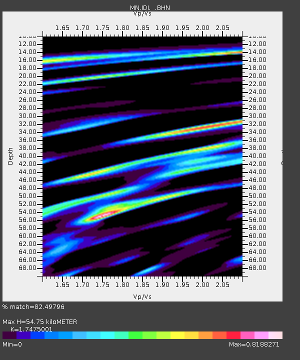
| Estimated Moho Depth: |
54.75 km |
| Estimated Crust Vp/Vs: |
1.75 |
| Assumed Crust Vp: |
5.627 km/s |
| Estimated Crust Vs: |
3.22 km/s |
| Estimated Crust Poisson's Ratio: |
0.26 |
|
| Radial Match: |
82.49796 % |
| Radial Bump: |
400 |
| Transverse Match: |
80.08695 % |
| Transverse Bump: |
400 |
| SOD ConfigId: |
2658 |
| Insert Time: |
2010-03-08 17:08:44.695 +0000 |
| GWidth: |
2.5 |
| Max Bumps: |
400 |
| Tol: |
0.001 |
|

Signal To Noise
| Channel | StoN | STA | LTA |
| MN:IDI: :BHN:20090407T04:35:38.446021Z | 27.848751 | 6.0359666E-6 | 2.1674101E-7 |
| MN:IDI: :BHE:20090407T04:35:38.446021Z | 20.030233 | 3.7707714E-6 | 1.8825399E-7 |
| MN:IDI: :BHZ:20090407T04:35:38.446021Z | 5.454441 | 1.5739931E-6 | 2.8857093E-7 |
| Arrivals |
| Ps | 7.4 SECOND |
| PpPs | 26 SECOND |
| PsPs/PpSs | 34 SECOND |


