You are here: Home > Network List > MN - MEDNET Project Stations List
> Station IDI Anogia, Greece > Earthquake Result Viewer
IDI Anogia, Greece - Earthquake Result Viewer

| Earthquake location: |
Near East Coast Of Honshu, Japan |
| Earthquake latitude/longitude: |
36.2/141.5 |
| Earthquake time(UTC): |
2008/05/07 (128) 16:02:02 GMT |
| Earthquake Depth: |
19 km |
| Earthquake Magnitude: |
5.7 MB, 6.2 MW, 6.2 MW |
| Earthquake Catalog/Contributor: |
WHDF/NEIC |
|
| Network: |
MN MEDNET Project |
| Station: |
IDI Anogia, Greece |
| Lat/Lon: |
35.29 N/24.89 E |
| Elevation: |
750 m |
|
| Distance: |
87.6 deg |
| Az: |
312.966 deg |
| Baz: |
46.36 deg |
| Ray Param: |
0.043159164 |
| Estimated Moho Depth: |
39.75 km |
| Estimated Crust Vp/Vs: |
2.10 |
| Assumed Crust Vp: |
5.627 km/s |
| Estimated Crust Vs: |
2.683 km/s |
| Estimated Crust Poisson's Ratio: |
0.35 |
|
| Radial Match: |
80.079315 % |
| Radial Bump: |
400 |
| Transverse Match: |
81.10348 % |
| Transverse Bump: |
400 |
| SOD ConfigId: |
2504 |
| Insert Time: |
2010-03-08 17:08:59.455 +0000 |
| GWidth: |
2.5 |
| Max Bumps: |
400 |
| Tol: |
0.001 |
|
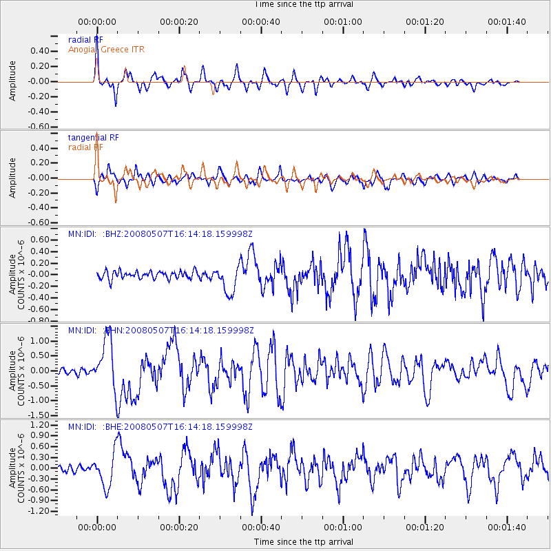
Signal To Noise
| Channel | StoN | STA | LTA |
| MN:IDI: :BHN:20080507T16:14:18.159998Z | 10.187008 | 8.901425E-7 | 8.7380165E-8 |
| MN:IDI: :BHE:20080507T16:14:18.159998Z | 6.596125 | 4.8417985E-7 | 7.3403676E-8 |
| MN:IDI: :BHZ:20080507T16:14:18.159998Z | 3.777496 | 2.4976515E-7 | 6.6119235E-8 |
| Arrivals |
| Ps | 7.9 SECOND |
| PpPs | 22 SECOND |
| PsPs/PpSs | 29 SECOND |


