You are here: Home > Network List > MN - MEDNET Project Stations List
> Station IDI Anogia, Greece > Earthquake Result Viewer
IDI Anogia, Greece - Earthquake Result Viewer

| Earthquake location: |
Kuril Islands |
| Earthquake latitude/longitude: |
46.4/153.2 |
| Earthquake time(UTC): |
2008/03/03 (063) 09:31:02 GMT |
| Earthquake Depth: |
10 km |
| Earthquake Magnitude: |
6.2 MB, 6.5 MS, 6.5 MW, 6.5 MW |
| Earthquake Catalog/Contributor: |
WHDF/NEIC |
|
| Network: |
MN MEDNET Project |
| Station: |
IDI Anogia, Greece |
| Lat/Lon: |
35.29 N/24.89 E |
| Elevation: |
750 m |
|
| Distance: |
86.3 deg |
| Az: |
319.948 deg |
| Baz: |
32.976 deg |
| Ray Param: |
0.044146493 |
| Estimated Moho Depth: |
62.5 km |
| Estimated Crust Vp/Vs: |
1.68 |
| Assumed Crust Vp: |
5.627 km/s |
| Estimated Crust Vs: |
3.354 km/s |
| Estimated Crust Poisson's Ratio: |
0.22 |
|
| Radial Match: |
84.064354 % |
| Radial Bump: |
400 |
| Transverse Match: |
83.46959 % |
| Transverse Bump: |
400 |
| SOD ConfigId: |
2564 |
| Insert Time: |
2010-03-08 17:09:15.786 +0000 |
| GWidth: |
2.5 |
| Max Bumps: |
400 |
| Tol: |
0.001 |
|
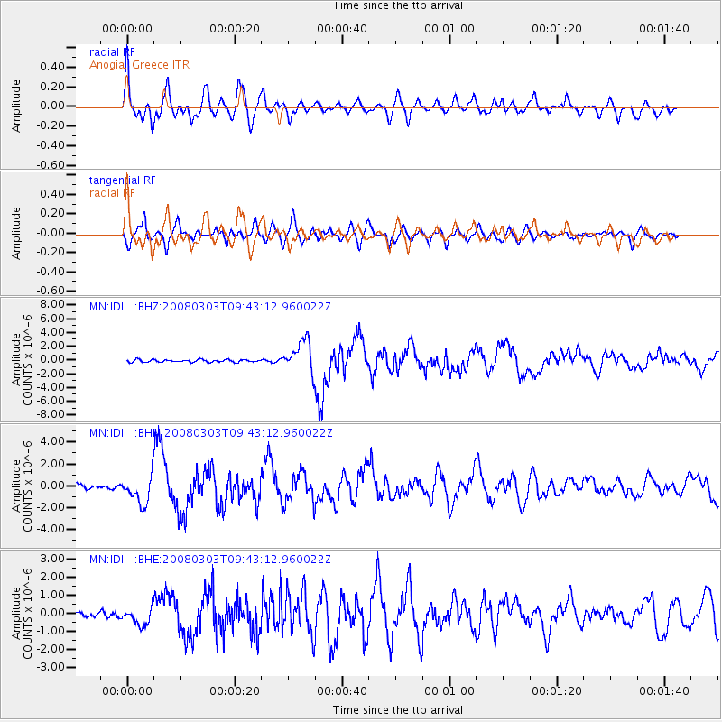
Signal To Noise
| Channel | StoN | STA | LTA |
| MN:IDI: :BHN:20080303T09:43:12.960022Z | 6.220181 | 1.2856399E-6 | 2.066885E-7 |
| MN:IDI: :BHE:20080303T09:43:12.960022Z | 2.55114 | 4.930577E-7 | 1.9326956E-7 |
| MN:IDI: :BHZ:20080303T09:43:12.960022Z | 12.657434 | 2.3055072E-6 | 1.821465E-7 |
| Arrivals |
| Ps | 7.7 SECOND |
| PpPs | 29 SECOND |
| PsPs/PpSs | 37 SECOND |


