You are here: Home > Network List > MN - MEDNET Project Stations List
> Station IDI Anogia, Greece > Earthquake Result Viewer
IDI Anogia, Greece - Earthquake Result Viewer
| Earthquake location: |
Luzon, Philippines |
| Earthquake latitude/longitude: |
14.5/120.0 |
| Earthquake time(UTC): |
1996/07/30 (212) 17:38:30 GMT |
| Earthquake Depth: |
33 km |
| Earthquake Magnitude: |
6.1 MB, 5.7 MS, 6.1 UNKNOWN, 5.9 MW |
| Earthquake Catalog/Contributor: |
WHDF/NEIC |
|
| Network: |
MN MEDNET Project |
| Station: |
IDI Anogia, Greece |
| Lat/Lon: |
35.29 N/24.89 E |
| Elevation: |
750 m |
|
| Distance: |
85.8 deg |
| Az: |
305.206 deg |
| Baz: |
75.314 deg |
| Ray Param: |
0.044462338 |
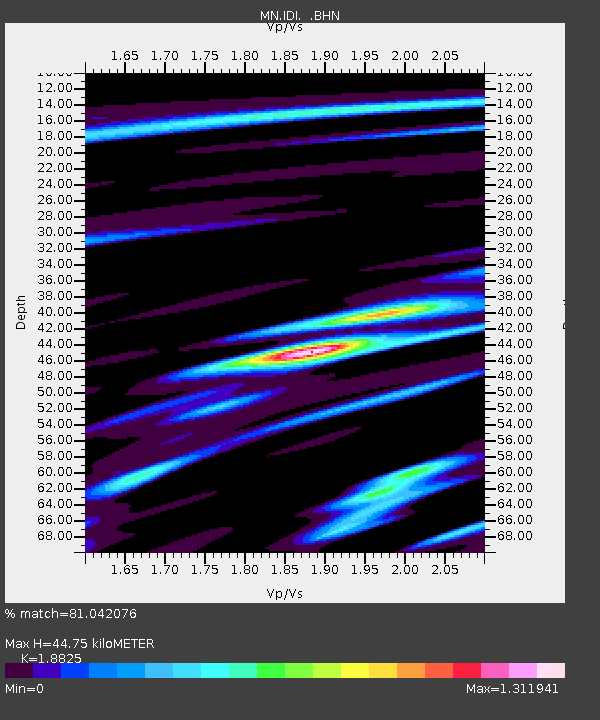
| Estimated Moho Depth: |
44.75 km |
| Estimated Crust Vp/Vs: |
1.88 |
| Assumed Crust Vp: |
5.627 km/s |
| Estimated Crust Vs: |
2.989 km/s |
| Estimated Crust Poisson's Ratio: |
0.30 |
|
| Radial Match: |
81.042076 % |
| Radial Bump: |
400 |
| Transverse Match: |
84.380455 % |
| Transverse Bump: |
400 |
| SOD ConfigId: |
6273 |
| Insert Time: |
2010-03-08 17:09:24.757 +0000 |
| GWidth: |
2.5 |
| Max Bumps: |
400 |
| Tol: |
0.001 |
|

Signal To Noise
| Channel | StoN | STA | LTA |
| MN:IDI: :BHN:19960730T17:50:35.540027Z | 7.2343273 | 4.6290702E-7 | 6.398757E-8 |
| MN:IDI: :BHE:19960730T17:50:35.540027Z | 7.316565 | 4.2719162E-7 | 5.8386906E-8 |
| MN:IDI: :BHZ:19960730T17:50:35.540027Z | 11.592404 | 1.0631236E-6 | 9.170864E-8 |
| Arrivals |
| Ps | 7.1 SECOND |
| PpPs | 23 SECOND |
| PsPs/PpSs | 30 SECOND |


