You are here: Home > Network List > MN - MEDNET Project Stations List
> Station IDI Anogia, Greece > Earthquake Result Viewer
IDI Anogia, Greece - Earthquake Result Viewer
| Earthquake location: |
Afghanistan-Tajikistan Bord Reg. |
| Earthquake latitude/longitude: |
36.4/71.1 |
| Earthquake time(UTC): |
2005/12/12 (346) 21:47:46 GMT |
| Earthquake Depth: |
225 km |
| Earthquake Magnitude: |
6.0 MB, 6.5 MW, 6.5 MW |
| Earthquake Catalog/Contributor: |
WHDF/NEIC |
|
| Network: |
MN MEDNET Project |
| Station: |
IDI Anogia, Greece |
| Lat/Lon: |
35.29 N/24.89 E |
| Elevation: |
750 m |
|
| Distance: |
37.2 deg |
| Az: |
282.421 deg |
| Baz: |
74.503 deg |
| Ray Param: |
0.0753982 |
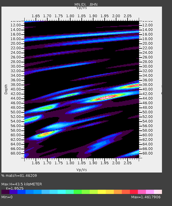
| Estimated Moho Depth: |
43.5 km |
| Estimated Crust Vp/Vs: |
1.95 |
| Assumed Crust Vp: |
5.627 km/s |
| Estimated Crust Vs: |
2.882 km/s |
| Estimated Crust Poisson's Ratio: |
0.32 |
|
| Radial Match: |
81.46209 % |
| Radial Bump: |
400 |
| Transverse Match: |
76.24183 % |
| Transverse Bump: |
400 |
| SOD ConfigId: |
2422 |
| Insert Time: |
2010-03-08 17:09:26.172 +0000 |
| GWidth: |
2.5 |
| Max Bumps: |
400 |
| Tol: |
0.001 |
|
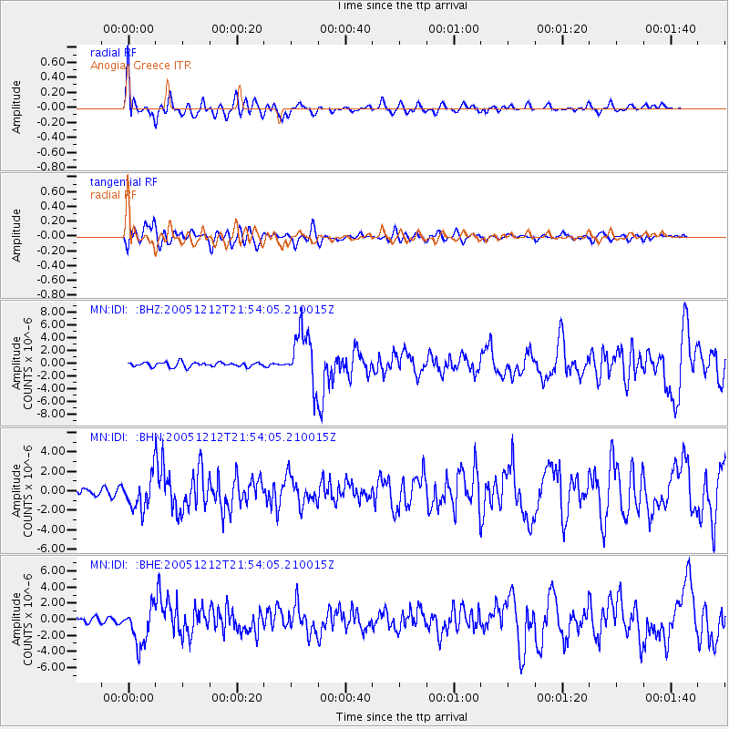
Signal To Noise
| Channel | StoN | STA | LTA |
| MN:IDI: :BHN:20051212T21:54:05.210015Z | 4.6239033 | 1.7253868E-6 | 3.731451E-7 |
| MN:IDI: :BHE:20051212T21:54:05.210015Z | 5.333547 | 2.4044148E-6 | 4.5080972E-7 |
| MN:IDI: :BHZ:20051212T21:54:05.210015Z | 12.278903 | 4.2279908E-6 | 3.4432966E-7 |
| Arrivals |
| Ps | 7.7 SECOND |
| PpPs | 22 SECOND |
| PsPs/PpSs | 29 SECOND |


