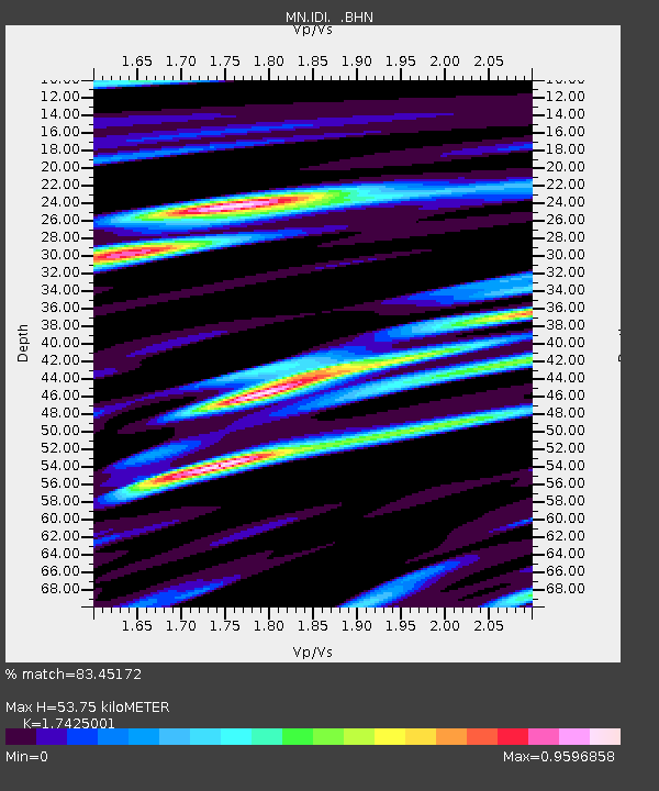
IDI Anogia, Greece - Earthquake Result Viewer

Earthquake location: Southern Sumatra, Indonesia
Earthquake latitude/longitude: -1.6/99.6
Earthquake time(UTC): 2005/04/10 (100) 10:29:11 GMT
Earthquake Depth: 19 km
Earthquake Magnitude: 6.4 MB, 6.7 MS, 6.7 MW, 6.6 MW
Earthquake Catalog/Contributor: WHDF/NEIC
Network: MN MEDNET Project
Station: IDI Anogia, Greece
Lat/Lon: 35.29 N/24.89 E
Elevation: 750 m
Distance: 78.5 deg
Az: 306.362 deg
Baz: 100.277 deg
Ray Param: 0.049574338
Estimated Moho Depth: 53.75 km
Estimated Crust Vp/Vs: 1.74
Assumed Crust Vp: 5.627 km/s
Estimated Crust Vs: 3.229 km/s
Estimated Crust Poisson's Ratio: 0.25
Radial Match: 83.45172 %
Radial Bump: 400
Transverse Match: 83.46694 %
Transverse Bump: 400
SOD ConfigId: 2459
Insert Time: 2010-03-08 17:09:31.966 +0000
GWidth: 2.5
Max Bumps: 400
Tol: 0.001

Signal To Noise

ChannelStoNSTALTA
MN:IDI: :BHN:20050410T10:40:39.824006Z1.41770141.285389E-79.066712E-8
MN:IDI: :BHE:20050410T10:40:39.824006Z9.1936168.25183E-78.975609E-8
MN:IDI: :BHZ:20050410T10:40:39.824006Z21.1086311.967381E-69.320267E-8
Arrivals
Ps7.3 SECOND
PpPs26 SECOND
PsPs/PpSs33 SECOND