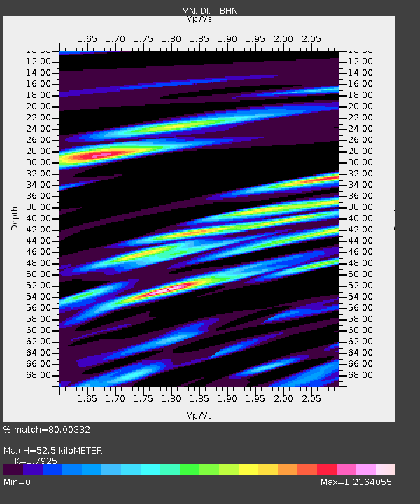
IDI Anogia, Greece - Earthquake Result Viewer
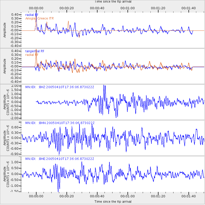
Earthquake location: Southern Sumatra, Indonesia
Earthquake latitude/longitude: -1.6/99.7
Earthquake time(UTC): 2005/04/10 (100) 17:24:39 GMT
Earthquake Depth: 30 km
Earthquake Magnitude: 5.9 MB, 6.2 MS, 6.4 MW, 6.1 MW
Earthquake Catalog/Contributor: WHDF/NEIC
Network: MN MEDNET Project
Station: IDI Anogia, Greece
Lat/Lon: 35.29 N/24.89 E
Elevation: 750 m
Distance: 78.6 deg
Az: 306.337 deg
Baz: 100.168 deg
Ray Param: 0.04951257
Estimated Moho Depth: 52.5 km
Estimated Crust Vp/Vs: 1.79
Assumed Crust Vp: 5.627 km/s
Estimated Crust Vs: 3.139 km/s
Estimated Crust Poisson's Ratio: 0.27
Radial Match: 80.00332 %
Radial Bump: 400
Transverse Match: 63.282265 %
Transverse Bump: 400
SOD ConfigId: 2459
Insert Time: 2010-03-08 17:09:34.169 +0000
GWidth: 2.5
Max Bumps: 400
Tol: 0.001

Signal To Noise

ChannelStoNSTALTA
MN:IDI: :BHN:20050410T17:36:06.873022Z1.76763841.4353546E-78.120182E-8
MN:IDI: :BHE:20050410T17:36:06.873022Z1.93951182.0570263E-71.0605898E-7
MN:IDI: :BHZ:20050410T17:36:06.873022Z3.12543873.7121478E-71.1877206E-7
Arrivals
Ps7.6 SECOND
PpPs25 SECOND
PsPs/PpSs33 SECOND